You are here: Home > Network List > PF - Volcanologic Network of Piton de Fournaise-OVPF Stations List
> Station GBS Grandes pentes coulee 1943 bas > Earthquake Result Viewer
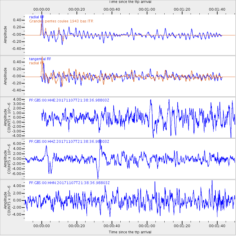
GBS Grandes pentes coulee 1943 bas - Earthquake Result Viewer
*The percent match for this event was below the threshold and hence no stack was calculated.
| Earthquake location: |
New Guinea, Papua New Guinea |
| Earthquake latitude/longitude: |
-4.2/143.5 |
| Earthquake time(UTC): |
2017/11/07 (311) 21:26:38 GMT |
| Earthquake Depth: |
107 km |
| Earthquake Magnitude: |
6.5 mww |
| Earthquake Catalog/Contributor: |
NEIC PDE/us |
|
| Network: |
PF Volcanologic Network of Piton de Fournaise-OVPF |
| Station: |
GBS Grandes pentes coulee 1943 bas |
| Lat/Lon: |
21.27 S/55.78 E |
| Elevation: |
471 m |
|
| Distance: |
86.3 deg |
| Az: |
249.039 deg |
| Baz: |
93.094 deg |
| Ray Param: |
$rayparam |
*The percent match for this event was below the threshold and hence was not used in the summary stack. |
|
| Radial Match: |
75.91651 % |
| Radial Bump: |
400 |
| Transverse Match: |
70.589516 % |
| Transverse Bump: |
400 |
| SOD ConfigId: |
2429771 |
| Insert Time: |
2017-11-21 21:28:49.218 +0000 |
| GWidth: |
2.5 |
| Max Bumps: |
400 |
| Tol: |
0.001 |
|
Signal To Noise
| Channel | StoN | STA | LTA |
| PF:GBS:00:HHZ:20171107T21:38:36.98803Z | 3.603302 | 2.5104698E-6 | 6.967137E-7 |
| PF:GBS:00:HHN:20171107T21:38:36.98803Z | 1.041534 | 9.749026E-7 | 9.3602574E-7 |
| PF:GBS:00:HHE:20171107T21:38:36.98803Z | 1.514612 | 1.2829627E-6 | 8.4705704E-7 |
| Arrivals |
| Ps | |
| PpPs | |
| PsPs/PpSs | |


