You are here: Home > Network List > PF - Volcanologic Network of Piton de Fournaise-OVPF Stations List
> Station GPS Grandes Pentes Sud > Earthquake Result Viewer
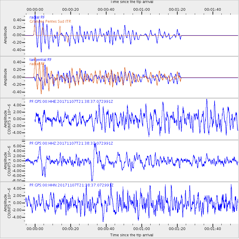
GPS Grandes Pentes Sud - Earthquake Result Viewer
*The percent match for this event was below the threshold and hence no stack was calculated.
| Earthquake location: |
New Guinea, Papua New Guinea |
| Earthquake latitude/longitude: |
-4.2/143.5 |
| Earthquake time(UTC): |
2017/11/07 (311) 21:26:38 GMT |
| Earthquake Depth: |
107 km |
| Earthquake Magnitude: |
6.5 mww |
| Earthquake Catalog/Contributor: |
NEIC PDE/us |
|
| Network: |
PF Volcanologic Network of Piton de Fournaise-OVPF |
| Station: |
GPS Grandes Pentes Sud |
| Lat/Lon: |
21.27 S/55.76 E |
| Elevation: |
1004 m |
|
| Distance: |
86.4 deg |
| Az: |
249.044 deg |
| Baz: |
93.1 deg |
| Ray Param: |
$rayparam |
*The percent match for this event was below the threshold and hence was not used in the summary stack. |
|
| Radial Match: |
74.92975 % |
| Radial Bump: |
400 |
| Transverse Match: |
71.43289 % |
| Transverse Bump: |
400 |
| SOD ConfigId: |
2429771 |
| Insert Time: |
2017-11-21 21:28:54.412 +0000 |
| GWidth: |
2.5 |
| Max Bumps: |
400 |
| Tol: |
0.001 |
|
Signal To Noise
| Channel | StoN | STA | LTA |
| PF:GPS:00:HHZ:20171107T21:38:37.072991Z | 3.836189 | 2.8361605E-6 | 7.3931716E-7 |
| PF:GPS:00:HHN:20171107T21:38:37.072991Z | 1.0993612 | 1.179422E-6 | 1.0728248E-6 |
| PF:GPS:00:HHE:20171107T21:38:37.072991Z | 1.3102012 | 1.4601757E-6 | 1.1144667E-6 |
| Arrivals |
| Ps | |
| PpPs | |
| PsPs/PpSs | |


