You are here: Home > Network List > PF - Volcanologic Network of Piton de Fournaise-OVPF Stations List
> Station HIM cratere Himiltrude > Earthquake Result Viewer
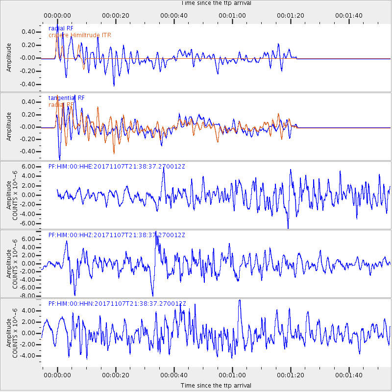
HIM cratere Himiltrude - Earthquake Result Viewer
*The percent match for this event was below the threshold and hence no stack was calculated.
| Earthquake location: |
New Guinea, Papua New Guinea |
| Earthquake latitude/longitude: |
-4.2/143.5 |
| Earthquake time(UTC): |
2017/11/07 (311) 21:26:38 GMT |
| Earthquake Depth: |
107 km |
| Earthquake Magnitude: |
6.5 mww |
| Earthquake Catalog/Contributor: |
NEIC PDE/us |
|
| Network: |
PF Volcanologic Network of Piton de Fournaise-OVPF |
| Station: |
HIM cratere Himiltrude |
| Lat/Lon: |
21.21 S/55.72 E |
| Elevation: |
1958 m |
|
| Distance: |
86.4 deg |
| Az: |
249.098 deg |
| Baz: |
93.119 deg |
| Ray Param: |
$rayparam |
*The percent match for this event was below the threshold and hence was not used in the summary stack. |
|
| Radial Match: |
64.53563 % |
| Radial Bump: |
400 |
| Transverse Match: |
63.215607 % |
| Transverse Bump: |
400 |
| SOD ConfigId: |
2429771 |
| Insert Time: |
2017-11-21 21:28:58.624 +0000 |
| GWidth: |
2.5 |
| Max Bumps: |
400 |
| Tol: |
0.001 |
|
Signal To Noise
| Channel | StoN | STA | LTA |
| PF:HIM:00:HHZ:20171107T21:38:37.270012Z | 3.341393 | 2.4564577E-6 | 7.3515974E-7 |
| PF:HIM:00:HHN:20171107T21:38:37.270012Z | 2.065134 | 2.1386393E-6 | 1.0355934E-6 |
| PF:HIM:00:HHE:20171107T21:38:37.270012Z | 1.5633223 | 1.4408002E-6 | 9.216271E-7 |
| Arrivals |
| Ps | |
| PpPs | |
| PsPs/PpSs | |


