You are here: Home > Network List > GE - GEOFON Stations List
> Station TIRR GEOFON Station Tirgusor, Romania > Earthquake Result Viewer
TIRR GEOFON Station Tirgusor, Romania - Earthquake Result Viewer
| Earthquake location: |
Southern Sumatra, Indonesia |
| Earthquake latitude/longitude: |
-0.7/99.9 |
| Earthquake time(UTC): |
2009/09/30 (273) 10:16:09 GMT |
| Earthquake Depth: |
81 km |
| Earthquake Magnitude: |
7.1 MB, 7.5 MW, 7.5 MW |
| Earthquake Catalog/Contributor: |
WHDF/NEIC |
|
| Network: |
GE GEOFON |
| Station: |
TIRR GEOFON Station Tirgusor, Romania |
| Lat/Lon: |
44.46 N/28.41 E |
| Elevation: |
77 m |
|
| Distance: |
77.3 deg |
| Az: |
315.907 deg |
| Baz: |
103.69 deg |
| Ray Param: |
0.050206684 |
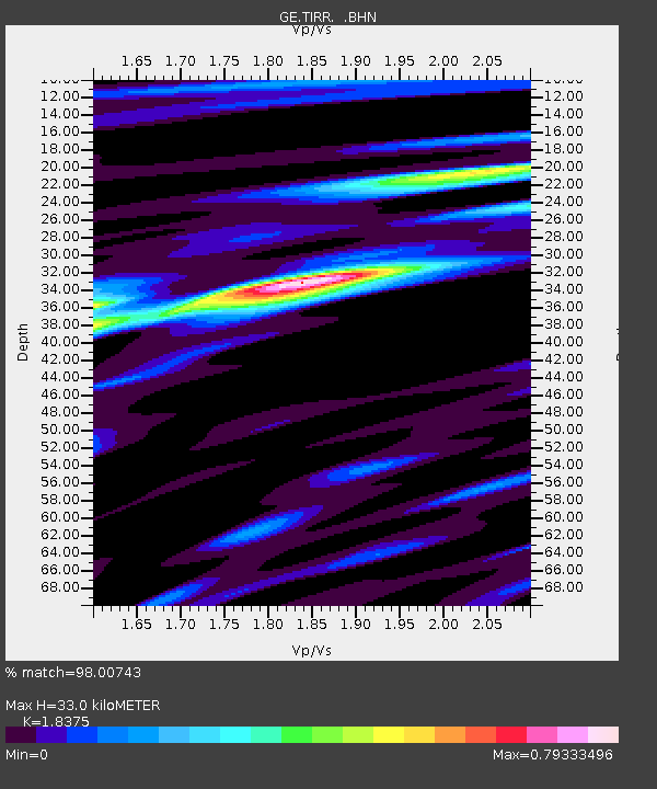
| Estimated Moho Depth: |
33.0 km |
| Estimated Crust Vp/Vs: |
1.84 |
| Assumed Crust Vp: |
6.12 km/s |
| Estimated Crust Vs: |
3.331 km/s |
| Estimated Crust Poisson's Ratio: |
0.29 |
|
| Radial Match: |
98.00743 % |
| Radial Bump: |
392 |
| Transverse Match: |
93.7079 % |
| Transverse Bump: |
400 |
| SOD ConfigId: |
2622 |
| Insert Time: |
2010-03-09 07:01:44.066 +0000 |
| GWidth: |
2.5 |
| Max Bumps: |
400 |
| Tol: |
0.001 |
|

Signal To Noise
| Channel | StoN | STA | LTA |
| GE:TIRR: :BHN:20090930T10:27:24.218994Z | 116.52432 | 2.0231431E-5 | 1.7362412E-7 |
| GE:TIRR: :BHE:20090930T10:27:24.229004Z | 38.035824 | 2.3670095E-6 | 6.223105E-8 |
| GE:TIRR: :BHZ:20090930T10:27:24.210022Z | 79.09397 | 8.184691E-6 | 1.03480595E-7 |
| Arrivals |
| Ps | 4.6 SECOND |
| PpPs | 15 SECOND |
| PsPs/PpSs | 20 SECOND |


