You are here: Home > Network List > TA - USArray Transportable Network (new EarthScope stations) Stations List
> Station POKR Poker Plat Research Range, AK, USA > Earthquake Result Viewer
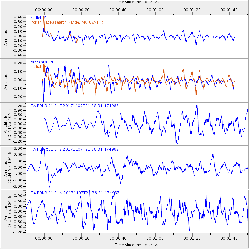
POKR Poker Plat Research Range, AK, USA - Earthquake Result Viewer
*The percent match for this event was below the threshold and hence no stack was calculated.
| Earthquake location: |
New Guinea, Papua New Guinea |
| Earthquake latitude/longitude: |
-4.2/143.5 |
| Earthquake time(UTC): |
2017/11/07 (311) 21:26:38 GMT |
| Earthquake Depth: |
107 km |
| Earthquake Magnitude: |
6.5 mww |
| Earthquake Catalog/Contributor: |
NEIC PDE/us |
|
| Network: |
TA USArray Transportable Network (new EarthScope stations) |
| Station: |
POKR Poker Plat Research Range, AK, USA |
| Lat/Lon: |
65.12 N/147.43 W |
| Elevation: |
501 m |
|
| Distance: |
85.2 deg |
| Az: |
23.368 deg |
| Baz: |
249.219 deg |
| Ray Param: |
$rayparam |
*The percent match for this event was below the threshold and hence was not used in the summary stack. |
|
| Radial Match: |
56.59018 % |
| Radial Bump: |
400 |
| Transverse Match: |
63.56244 % |
| Transverse Bump: |
400 |
| SOD ConfigId: |
2429771 |
| Insert Time: |
2017-11-21 21:29:15.537 +0000 |
| GWidth: |
2.5 |
| Max Bumps: |
400 |
| Tol: |
0.001 |
|
Signal To Noise
| Channel | StoN | STA | LTA |
| TA:POKR:01:BHZ:20171107T21:38:31.17498Z | 6.1322803 | 2.0537968E-6 | 3.3491568E-7 |
| TA:POKR:01:BHN:20171107T21:38:31.17498Z | 1.0144898 | 3.4954135E-7 | 3.4454894E-7 |
| TA:POKR:01:BHE:20171107T21:38:31.17498Z | 2.2590728 | 5.89656E-7 | 2.6101682E-7 |
| Arrivals |
| Ps | |
| PpPs | |
| PsPs/PpSs | |


