You are here: Home > Network List > WY - Yellowstone Wyoming Seismic Network Stations List
> Station YHH Holmes Hill, YNP, WY, USA > Earthquake Result Viewer
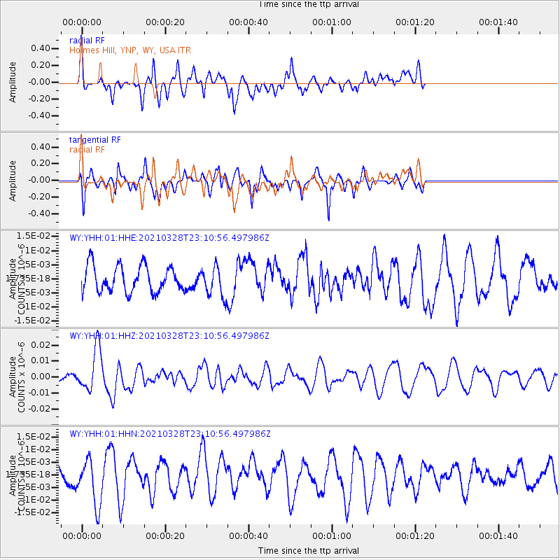
YHH Holmes Hill, YNP, WY, USA - Earthquake Result Viewer
*The percent match for this event was below the threshold and hence no stack was calculated.
| Earthquake location: |
Northern Mid-Atlantic Ridge |
| Earthquake latitude/longitude: |
43.6/-28.8 |
| Earthquake time(UTC): |
2021/03/28 (087) 23:01:46 GMT |
| Earthquake Depth: |
10 km |
| Earthquake Magnitude: |
5.8 Mww |
| Earthquake Catalog/Contributor: |
NEIC PDE/us |
|
| Network: |
WY Yellowstone Wyoming Seismic Network |
| Station: |
YHH Holmes Hill, YNP, WY, USA |
| Lat/Lon: |
44.79 N/110.85 W |
| Elevation: |
2717 m |
|
| Distance: |
56.3 deg |
| Az: |
302.083 deg |
| Baz: |
59.744 deg |
| Ray Param: |
$rayparam |
*The percent match for this event was below the threshold and hence was not used in the summary stack. |
|
| Radial Match: |
59.34185 % |
| Radial Bump: |
400 |
| Transverse Match: |
71.35014 % |
| Transverse Bump: |
400 |
| SOD ConfigId: |
24334971 |
| Insert Time: |
2021-04-11 23:34:38.509 +0000 |
| GWidth: |
2.5 |
| Max Bumps: |
400 |
| Tol: |
0.001 |
|
Signal To Noise
| Channel | StoN | STA | LTA |
| WY:YHH:01:HHZ:20210328T23:10:56.497986Z | 3.8837001 | 1.3829293E-8 | 3.5608552E-9 |
| WY:YHH:01:HHN:20210328T23:10:56.497986Z | 1.7137549 | 9.4179295E-9 | 5.495494E-9 |
| WY:YHH:01:HHE:20210328T23:10:56.497986Z | 1.170828 | 5.3761626E-9 | 4.591761E-9 |
| Arrivals |
| Ps | |
| PpPs | |
| PsPs/PpSs | |


