You are here: Home > Network List > GE - GEOFON Stations List
> Station TIRR GEOFON Station Tirgusor, Romania > Earthquake Result Viewer
TIRR GEOFON Station Tirgusor, Romania - Earthquake Result Viewer
| Earthquake location: |
Taiwan Region |
| Earthquake latitude/longitude: |
24.2/122.5 |
| Earthquake time(UTC): |
2006/07/28 (209) 07:40:13 GMT |
| Earthquake Depth: |
49 km |
| Earthquake Magnitude: |
5.7 MB, 5.9 MW, 5.8 MW |
| Earthquake Catalog/Contributor: |
WHDF/NEIC |
|
| Network: |
GE GEOFON |
| Station: |
TIRR GEOFON Station Tirgusor, Romania |
| Lat/Lon: |
44.46 N/28.41 E |
| Elevation: |
77 m |
|
| Distance: |
76.3 deg |
| Az: |
312.669 deg |
| Baz: |
69.666 deg |
| Ray Param: |
0.051019453 |
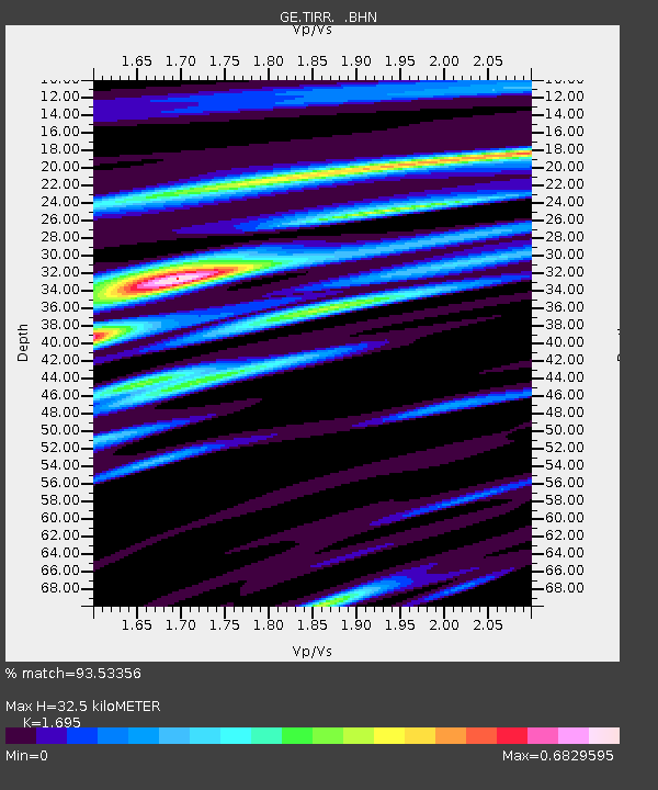
| Estimated Moho Depth: |
32.5 km |
| Estimated Crust Vp/Vs: |
1.70 |
| Assumed Crust Vp: |
6.12 km/s |
| Estimated Crust Vs: |
3.611 km/s |
| Estimated Crust Poisson's Ratio: |
0.23 |
|
| Radial Match: |
93.53356 % |
| Radial Bump: |
400 |
| Transverse Match: |
81.437325 % |
| Transverse Bump: |
400 |
| SOD ConfigId: |
2665 |
| Insert Time: |
2010-03-09 07:02:30.600 +0000 |
| GWidth: |
2.5 |
| Max Bumps: |
400 |
| Tol: |
0.001 |
|

Signal To Noise
| Channel | StoN | STA | LTA |
| GE:TIRR: :BHN:20060728T07:51:26.250Z | 3.5844781 | 1.0669276E-7 | 2.9765213E-8 |
| GE:TIRR: :BHE:20060728T07:51:26.229004Z | 9.319975 | 3.259602E-7 | 3.4974363E-8 |
| GE:TIRR: :BHZ:20060728T07:51:26.239014Z | 13.607058 | 8.6863275E-7 | 6.383693E-8 |
| Arrivals |
| Ps | 3.8 SECOND |
| PpPs | 14 SECOND |
| PsPs/PpSs | 18 SECOND |


