You are here: Home > Network List > II - Global Seismograph Network (GSN - IRIS/IDA) Stations List
> Station WRAB Tennant Creek, NT, Australia > Earthquake Result Viewer
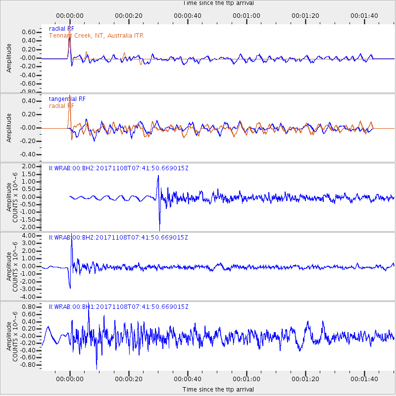
WRAB Tennant Creek, NT, Australia - Earthquake Result Viewer
*The percent match for this event was below the threshold and hence no stack was calculated.
| Earthquake location: |
Fiji Islands Region |
| Earthquake latitude/longitude: |
-21.9/-179.4 |
| Earthquake time(UTC): |
2017/11/08 (312) 07:35:11 GMT |
| Earthquake Depth: |
583 km |
| Earthquake Magnitude: |
5.7 Mww |
| Earthquake Catalog/Contributor: |
NEIC PDE/us |
|
| Network: |
II Global Seismograph Network (GSN - IRIS/IDA) |
| Station: |
WRAB Tennant Creek, NT, Australia |
| Lat/Lon: |
19.93 S/134.36 E |
| Elevation: |
366 m |
|
| Distance: |
43.1 deg |
| Az: |
263.798 deg |
| Baz: |
101.007 deg |
| Ray Param: |
$rayparam |
*The percent match for this event was below the threshold and hence was not used in the summary stack. |
|
| Radial Match: |
72.89692 % |
| Radial Bump: |
400 |
| Transverse Match: |
66.51344 % |
| Transverse Bump: |
400 |
| SOD ConfigId: |
2429771 |
| Insert Time: |
2017-11-22 07:36:25.245 +0000 |
| GWidth: |
2.5 |
| Max Bumps: |
400 |
| Tol: |
0.001 |
|
Signal To Noise
| Channel | StoN | STA | LTA |
| II:WRAB:00:BHZ:20171108T07:41:50.669015Z | 10.463198 | 1.2674775E-6 | 1.2113671E-7 |
| II:WRAB:00:BH1:20171108T07:41:50.669015Z | 1.8170812 | 2.0582078E-7 | 1.1326999E-7 |
| II:WRAB:00:BH2:20171108T07:41:50.669015Z | 6.4297223 | 6.621044E-7 | 1.02975584E-7 |
| Arrivals |
| Ps | |
| PpPs | |
| PsPs/PpSs | |


