You are here: Home > Network List > IU - Global Seismograph Network (GSN - IRIS/USGS) Stations List
> Station PMG Port Moresby, New Guinea > Earthquake Result Viewer
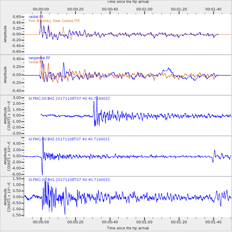
PMG Port Moresby, New Guinea - Earthquake Result Viewer
*The percent match for this event was below the threshold and hence no stack was calculated.
| Earthquake location: |
Fiji Islands Region |
| Earthquake latitude/longitude: |
-21.9/-179.4 |
| Earthquake time(UTC): |
2017/11/08 (312) 07:35:11 GMT |
| Earthquake Depth: |
583 km |
| Earthquake Magnitude: |
5.7 Mww |
| Earthquake Catalog/Contributor: |
NEIC PDE/us |
|
| Network: |
IU Global Seismograph Network (GSN - IRIS/USGS) |
| Station: |
PMG Port Moresby, New Guinea |
| Lat/Lon: |
9.40 S/147.16 E |
| Elevation: |
90 m |
|
| Distance: |
34.4 deg |
| Az: |
285.836 deg |
| Baz: |
115.081 deg |
| Ray Param: |
$rayparam |
*The percent match for this event was below the threshold and hence was not used in the summary stack. |
|
| Radial Match: |
83.02503 % |
| Radial Bump: |
400 |
| Transverse Match: |
67.53429 % |
| Transverse Bump: |
400 |
| SOD ConfigId: |
2429771 |
| Insert Time: |
2017-11-22 07:36:45.379 +0000 |
| GWidth: |
2.5 |
| Max Bumps: |
400 |
| Tol: |
0.001 |
|
Signal To Noise
| Channel | StoN | STA | LTA |
| IU:PMG:00:BHZ:20171108T07:40:40.719003Z | 27.944674 | 1.928373E-6 | 6.900682E-8 |
| IU:PMG:00:BH1:20171108T07:40:40.719003Z | 3.4358644 | 6.0302915E-7 | 1.7551017E-7 |
| IU:PMG:00:BH2:20171108T07:40:40.719003Z | 10.421044 | 1.0879387E-6 | 1.0439823E-7 |
| Arrivals |
| Ps | |
| PpPs | |
| PsPs/PpSs | |


