You are here: Home > Network List > GE - GEOFON Stations List
> Station TIRR GEOFON Station Tirgusor, Romania > Earthquake Result Viewer
TIRR GEOFON Station Tirgusor, Romania - Earthquake Result Viewer
| Earthquake location: |
Taiwan Region |
| Earthquake latitude/longitude: |
24.5/122.7 |
| Earthquake time(UTC): |
2004/10/15 (289) 04:08:50 GMT |
| Earthquake Depth: |
94 km |
| Earthquake Magnitude: |
6.4 MB, 6.7 MW, 6.6 MW |
| Earthquake Catalog/Contributor: |
WHDF/NEIC |
|
| Network: |
GE GEOFON |
| Station: |
TIRR GEOFON Station Tirgusor, Romania |
| Lat/Lon: |
44.46 N/28.41 E |
| Elevation: |
77 m |
|
| Distance: |
76.1 deg |
| Az: |
312.649 deg |
| Baz: |
69.305 deg |
| Ray Param: |
0.050977055 |
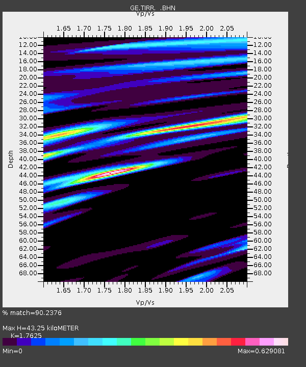
| Estimated Moho Depth: |
43.25 km |
| Estimated Crust Vp/Vs: |
1.76 |
| Assumed Crust Vp: |
6.12 km/s |
| Estimated Crust Vs: |
3.472 km/s |
| Estimated Crust Poisson's Ratio: |
0.26 |
|
| Radial Match: |
90.2376 % |
| Radial Bump: |
400 |
| Transverse Match: |
63.490803 % |
| Transverse Bump: |
400 |
| SOD ConfigId: |
2459 |
| Insert Time: |
2010-03-09 07:03:17.187 +0000 |
| GWidth: |
2.5 |
| Max Bumps: |
400 |
| Tol: |
0.001 |
|

Signal To Noise
| Channel | StoN | STA | LTA |
| GE:TIRR: :BHN:20041015T04:19:57.00001Z | 2.0679255 | 2.1660723E-7 | 1.0474615E-7 |
| GE:TIRR: :BHE:20041015T04:19:57.00001Z | 4.6409845 | 7.1904225E-7 | 1.5493313E-7 |
| GE:TIRR: :BHZ:20041015T04:19:57.01002Z | 7.602861 | 1.8523363E-6 | 2.4363675E-7 |
| Arrivals |
| Ps | 5.5 SECOND |
| PpPs | 19 SECOND |
| PsPs/PpSs | 25 SECOND |


