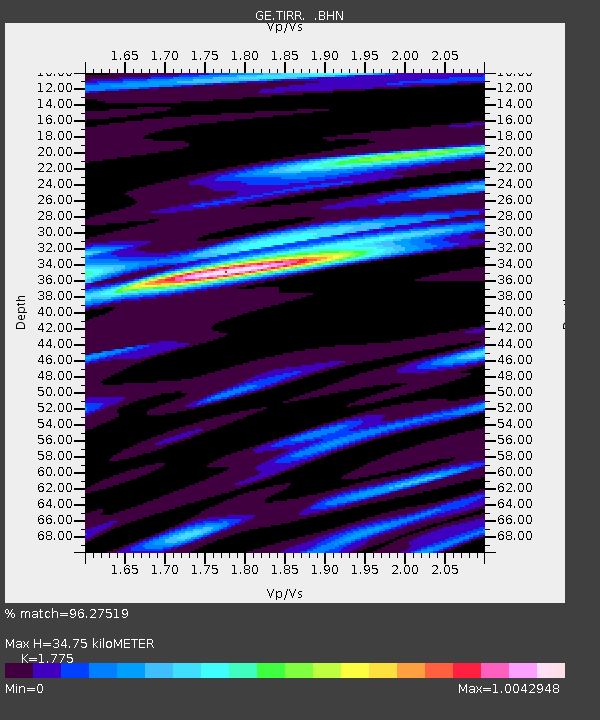
TIRR GEOFON Station Tirgusor, Romania - Earthquake Result Viewer

Earthquake location: Southern Sumatra, Indonesia
Earthquake latitude/longitude: -3.1/100.5
Earthquake time(UTC): 2009/04/15 (105) 20:01:34 GMT
Earthquake Depth: 20 km
Earthquake Magnitude: 6.1 MB, 6.4 MS, 6.4 MW, 6.2 MW
Earthquake Catalog/Contributor: WHDF/NEIC
Network: GE GEOFON
Station: TIRR GEOFON Station Tirgusor, Romania
Lat/Lon: 44.46 N/28.41 E
Elevation: 77 m
Distance: 79.5 deg
Az: 316.138 deg
Baz: 104.936 deg
Ray Param: 0.048914563
Estimated Moho Depth: 34.75 km
Estimated Crust Vp/Vs: 1.77
Assumed Crust Vp: 6.12 km/s
Estimated Crust Vs: 3.448 km/s
Estimated Crust Poisson's Ratio: 0.27
Radial Match: 96.27519 %
Radial Bump: 329
Transverse Match: 91.36281 %
Transverse Bump: 400
SOD ConfigId: 2658
Insert Time: 2010-03-09 07:03:46.776 +0000
GWidth: 2.5
Max Bumps: 400
Tol: 0.001

Signal To Noise

ChannelStoNSTALTA
GE:TIRR: :BHN:20090415T20:13:08.070002Z15.3609331.3566676E-68.831934E-8
GE:TIRR: :BHE:20090415T20:13:08.070002Z5.182621.5410679E-72.9735302E-8
GE:TIRR: :BHZ:20090415T20:13:08.090022Z11.4599365.232342E-74.5657682E-8
Arrivals
Ps4.5 SECOND
PpPs15 SECOND
PsPs/PpSs20 SECOND