You are here: Home > Network List > GE - GEOFON Stations List
> Station TIRR GEOFON Station Tirgusor, Romania > Earthquake Result Viewer
TIRR GEOFON Station Tirgusor, Romania - Earthquake Result Viewer
| Earthquake location: |
Kuril Islands |
| Earthquake latitude/longitude: |
47.0/153.9 |
| Earthquake time(UTC): |
2005/08/01 (213) 04:40:36 GMT |
| Earthquake Depth: |
17 km |
| Earthquake Magnitude: |
5.4 MB, 5.1 MS, 5.7 MW, 5.7 MW |
| Earthquake Catalog/Contributor: |
WHDF/NEIC |
|
| Network: |
GE GEOFON |
| Station: |
TIRR GEOFON Station Tirgusor, Romania |
| Lat/Lon: |
44.46 N/28.41 E |
| Elevation: |
77 m |
|
| Distance: |
77.0 deg |
| Az: |
323.256 deg |
| Baz: |
34.879 deg |
| Ray Param: |
0.05057469 |
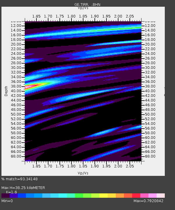
| Estimated Moho Depth: |
38.25 km |
| Estimated Crust Vp/Vs: |
1.60 |
| Assumed Crust Vp: |
6.12 km/s |
| Estimated Crust Vs: |
3.825 km/s |
| Estimated Crust Poisson's Ratio: |
0.18 |
|
| Radial Match: |
93.34148 % |
| Radial Bump: |
400 |
| Transverse Match: |
91.86593 % |
| Transverse Bump: |
400 |
| SOD ConfigId: |
2422 |
| Insert Time: |
2010-03-09 07:04:02.338 +0000 |
| GWidth: |
2.5 |
| Max Bumps: |
400 |
| Tol: |
0.001 |
|

Signal To Noise
| Channel | StoN | STA | LTA |
| GE:TIRR: :BHN:20050801T04:51:57.410012Z | 7.077854 | 1.6111227E-7 | 2.2762869E-8 |
| GE:TIRR: :BHE:20050801T04:51:57.420022Z | 6.292115 | 1.5655493E-7 | 2.488113E-8 |
| GE:TIRR: :BHZ:20050801T04:51:57.410012Z | 15.230588 | 5.819318E-7 | 3.8208096E-8 |
| Arrivals |
| Ps | 3.9 SECOND |
| PpPs | 16 SECOND |
| PsPs/PpSs | 20 SECOND |


