You are here: Home > Network List > IU - Global Seismograph Network (GSN - IRIS/USGS) Stations List
> Station PMG Port Moresby, New Guinea > Earthquake Result Viewer
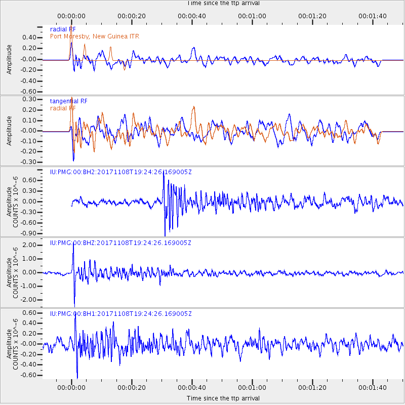
PMG Port Moresby, New Guinea - Earthquake Result Viewer
*The percent match for this event was below the threshold and hence no stack was calculated.
| Earthquake location: |
Sunda Strait, Indonesia |
| Earthquake latitude/longitude: |
-6.5/104.6 |
| Earthquake time(UTC): |
2017/11/08 (312) 19:17:07 GMT |
| Earthquake Depth: |
39 km |
| Earthquake Magnitude: |
5.1 Mww |
| Earthquake Catalog/Contributor: |
NEIC PDE/us |
|
| Network: |
IU Global Seismograph Network (GSN - IRIS/USGS) |
| Station: |
PMG Port Moresby, New Guinea |
| Lat/Lon: |
9.40 S/147.16 E |
| Elevation: |
90 m |
|
| Distance: |
42.2 deg |
| Az: |
96.785 deg |
| Baz: |
270.653 deg |
| Ray Param: |
$rayparam |
*The percent match for this event was below the threshold and hence was not used in the summary stack. |
|
| Radial Match: |
71.7253 % |
| Radial Bump: |
400 |
| Transverse Match: |
66.19355 % |
| Transverse Bump: |
400 |
| SOD ConfigId: |
2429771 |
| Insert Time: |
2017-11-22 19:18:01.106 +0000 |
| GWidth: |
2.5 |
| Max Bumps: |
400 |
| Tol: |
0.001 |
|
Signal To Noise
| Channel | StoN | STA | LTA |
| IU:PMG:00:BHZ:20171108T19:24:26.169005Z | 10.929836 | 7.4346957E-7 | 6.802202E-8 |
| IU:PMG:00:BH1:20171108T19:24:26.169005Z | 2.6551967 | 2.2135704E-7 | 8.3367475E-8 |
| IU:PMG:00:BH2:20171108T19:24:26.169005Z | 8.28231 | 4.287577E-7 | 5.176789E-8 |
| Arrivals |
| Ps | |
| PpPs | |
| PsPs/PpSs | |


