You are here: Home > Network List > TA - USArray Transportable Network (new EarthScope stations) Stations List
> Station H31M Peel River, Yukon, CAN > Earthquake Result Viewer
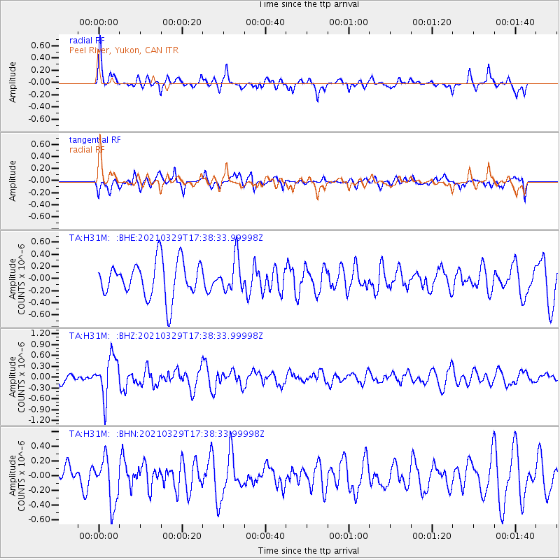
H31M Peel River, Yukon, CAN - Earthquake Result Viewer
*The percent match for this event was below the threshold and hence no stack was calculated.
| Earthquake location: |
Xizang |
| Earthquake latitude/longitude: |
34.4/87.7 |
| Earthquake time(UTC): |
2021/03/29 (088) 17:27:23 GMT |
| Earthquake Depth: |
10 km |
| Earthquake Magnitude: |
5.6 mww |
| Earthquake Catalog/Contributor: |
NEIC PDE/us |
|
| Network: |
TA USArray Transportable Network (new EarthScope stations) |
| Station: |
H31M Peel River, Yukon, CAN |
| Lat/Lon: |
65.81 N/134.34 W |
| Elevation: |
642 m |
|
| Distance: |
75.0 deg |
| Az: |
16.608 deg |
| Baz: |
324.985 deg |
| Ray Param: |
$rayparam |
*The percent match for this event was below the threshold and hence was not used in the summary stack. |
|
| Radial Match: |
66.85858 % |
| Radial Bump: |
352 |
| Transverse Match: |
36.99275 % |
| Transverse Bump: |
380 |
| SOD ConfigId: |
24334971 |
| Insert Time: |
2021-04-12 17:40:58.549 +0000 |
| GWidth: |
2.5 |
| Max Bumps: |
400 |
| Tol: |
0.001 |
|
Signal To Noise
| Channel | StoN | STA | LTA |
| TA:H31M: :BHZ:20210329T17:38:33.99998Z | 3.4678528 | 5.7924916E-7 | 1.6703395E-7 |
| TA:H31M: :BHN:20210329T17:38:33.99998Z | 2.1166627 | 3.19952E-7 | 1.5115872E-7 |
| TA:H31M: :BHE:20210329T17:38:33.99998Z | 0.942975 | 2.815713E-7 | 2.9859888E-7 |
| Arrivals |
| Ps | |
| PpPs | |
| PsPs/PpSs | |


