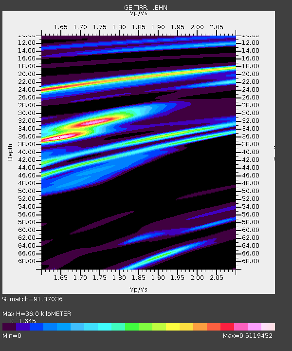
TIRR GEOFON Station Tirgusor, Romania - Earthquake Result Viewer

Earthquake location: Off East Coast Of Honshu, Japan
Earthquake latitude/longitude: 34.1/141.5
Earthquake time(UTC): 2005/01/19 (019) 06:11:36 GMT
Earthquake Depth: 28 km
Earthquake Magnitude: 5.8 MB, 6.4 MS, 6.5 MW, 6.4 MW
Earthquake Catalog/Contributor: WHDF/NEIC
Network: GE GEOFON
Station: TIRR GEOFON Station Tirgusor, Romania
Lat/Lon: 44.46 N/28.41 E
Elevation: 77 m
Distance: 81.0 deg
Az: 318.166 deg
Baz: 50.642 deg
Ray Param: 0.04784721
Estimated Moho Depth: 36.0 km
Estimated Crust Vp/Vs: 1.64
Assumed Crust Vp: 6.12 km/s
Estimated Crust Vs: 3.72 km/s
Estimated Crust Poisson's Ratio: 0.21
Radial Match: 91.37036 %
Radial Bump: 339
Transverse Match: 53.997665 %
Transverse Bump: 400
SOD ConfigId: 5233
Insert Time: 2010-03-09 07:04:17.535 +0000
GWidth: 2.5
Max Bumps: 400
Tol: 0.001

Signal To Noise

ChannelStoNSTALTA
GE:TIRR: :BHN:20050119T06:23:17.368994Z2.85392122.7804361E-79.742512E-8
GE:TIRR: :BHE:20050119T06:23:17.368994Z1.99663752.7805314E-71.392607E-7
GE:TIRR: :BHZ:20050119T06:23:17.360022Z5.21893649.973054E-71.9109362E-7
Arrivals
Ps3.9 SECOND
PpPs15 SECOND
PsPs/PpSs19 SECOND