You are here: Home > Network List > GE - GEOFON Stations List
> Station TIRR GEOFON Station Tirgusor, Romania > Earthquake Result Viewer
TIRR GEOFON Station Tirgusor, Romania - Earthquake Result Viewer
| Earthquake location: |
Xizang |
| Earthquake latitude/longitude: |
30.5/83.7 |
| Earthquake time(UTC): |
2005/04/07 (097) 20:04:41 GMT |
| Earthquake Depth: |
11 km |
| Earthquake Magnitude: |
6.0 MB, 6.1 MS, 6.3 MW, 6.2 MW |
| Earthquake Catalog/Contributor: |
WHDF/NEIC |
|
| Network: |
GE GEOFON |
| Station: |
TIRR GEOFON Station Tirgusor, Romania |
| Lat/Lon: |
44.46 N/28.41 E |
| Elevation: |
77 m |
|
| Distance: |
45.2 deg |
| Az: |
303.969 deg |
| Baz: |
88.537 deg |
| Ray Param: |
0.07143823 |
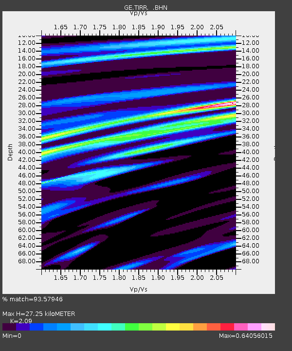
| Estimated Moho Depth: |
27.25 km |
| Estimated Crust Vp/Vs: |
2.09 |
| Assumed Crust Vp: |
6.12 km/s |
| Estimated Crust Vs: |
2.928 km/s |
| Estimated Crust Poisson's Ratio: |
0.35 |
|
| Radial Match: |
93.57946 % |
| Radial Bump: |
273 |
| Transverse Match: |
76.14285 % |
| Transverse Bump: |
400 |
| SOD ConfigId: |
2459 |
| Insert Time: |
2010-03-09 07:04:27.900 +0000 |
| GWidth: |
2.5 |
| Max Bumps: |
400 |
| Tol: |
0.001 |
|

Signal To Noise
| Channel | StoN | STA | LTA |
| GE:TIRR: :BHN:20050407T20:12:27.019015Z | 0.83146155 | 8.6445624E-8 | 1.0396828E-7 |
| GE:TIRR: :BHE:20050407T20:12:26.980013Z | 9.756104 | 7.205325E-7 | 7.385453E-8 |
| GE:TIRR: :BHZ:20050407T20:12:27.019015Z | 9.221968 | 1.1051101E-6 | 1.1983452E-7 |
| Arrivals |
| Ps | 5.1 SECOND |
| PpPs | 13 SECOND |
| PsPs/PpSs | 18 SECOND |


