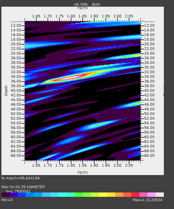
TIRR GEOFON Station Tirgusor, Romania - Earthquake Result Viewer

Earthquake location: Northern Sumatra, Indonesia
Earthquake latitude/longitude: 2.1/96.8
Earthquake time(UTC): 2005/04/28 (118) 14:07:33 GMT
Earthquake Depth: 22 km
Earthquake Magnitude: 5.9 MB, 6.2 MS, 6.3 MW, 6.2 MW
Earthquake Catalog/Contributor: WHDF/NEIC
Network: GE GEOFON
Station: TIRR GEOFON Station Tirgusor, Romania
Lat/Lon: 44.46 N/28.41 E
Elevation: 77 m
Distance: 73.2 deg
Az: 315.931 deg
Baz: 103.932 deg
Ray Param: 0.05315118
Estimated Moho Depth: 34.25 km
Estimated Crust Vp/Vs: 1.80
Assumed Crust Vp: 6.12 km/s
Estimated Crust Vs: 3.409 km/s
Estimated Crust Poisson's Ratio: 0.27
Radial Match: 95.644196 %
Radial Bump: 390
Transverse Match: 91.350685 %
Transverse Bump: 400
SOD ConfigId: 2459
Insert Time: 2010-03-09 07:04:34.232 +0000
GWidth: 2.5
Max Bumps: 400
Tol: 0.001

Signal To Noise

ChannelStoNSTALTA
GE:TIRR: :BHN:20050428T14:18:31.450Z3.35687421.0162093E-73.0272485E-8
GE:TIRR: :BHE:20050428T14:18:31.450Z8.4324242.7737536E-73.2893904E-8
GE:TIRR: :BHZ:20050428T14:18:31.450Z12.7747176.016633E-74.7097977E-8
Arrivals
Ps4.6 SECOND
PpPs15 SECOND
PsPs/PpSs20 SECOND