You are here: Home > Network List > US - United States National Seismic Network Stations List
> Station HAWA Hanford, Washington, USA > Earthquake Result Viewer
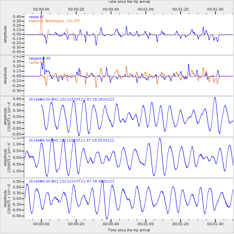
HAWA Hanford, Washington, USA - Earthquake Result Viewer
*The percent match for this event was below the threshold and hence no stack was calculated.
| Earthquake location: |
Southern East Pacific Rise |
| Earthquake latitude/longitude: |
-35.4/-106.0 |
| Earthquake time(UTC): |
2021/03/30 (089) 21:35:48 GMT |
| Earthquake Depth: |
10 km |
| Earthquake Magnitude: |
5.8 mww |
| Earthquake Catalog/Contributor: |
NEIC PDE/us |
|
| Network: |
US United States National Seismic Network |
| Station: |
HAWA Hanford, Washington, USA |
| Lat/Lon: |
46.39 N/119.53 W |
| Elevation: |
364 m |
|
| Distance: |
82.3 deg |
| Az: |
350.618 deg |
| Baz: |
168.906 deg |
| Ray Param: |
$rayparam |
*The percent match for this event was below the threshold and hence was not used in the summary stack. |
|
| Radial Match: |
58.228336 % |
| Radial Bump: |
400 |
| Transverse Match: |
59.37484 % |
| Transverse Bump: |
400 |
| SOD ConfigId: |
24334971 |
| Insert Time: |
2021-04-13 21:50:39.730 +0000 |
| GWidth: |
2.5 |
| Max Bumps: |
400 |
| Tol: |
0.001 |
|
Signal To Noise
| Channel | StoN | STA | LTA |
| US:HAWA:00:BHZ:20210330T21:47:38.950012Z | 2.1513839 | 8.928611E-7 | 4.1501713E-7 |
| US:HAWA:00:BH1:20210330T21:47:38.950012Z | 0.695023 | 3.0296158E-7 | 4.359015E-7 |
| US:HAWA:00:BH2:20210330T21:47:38.950012Z | 0.8466333 | 4.4392408E-7 | 5.243404E-7 |
| Arrivals |
| Ps | |
| PpPs | |
| PsPs/PpSs | |


