You are here: Home > Network List > AV - Alaska Volcano Observatory Stations List
> Station PLBL Mt. Peulik Volcano, Alaska > Earthquake Result Viewer
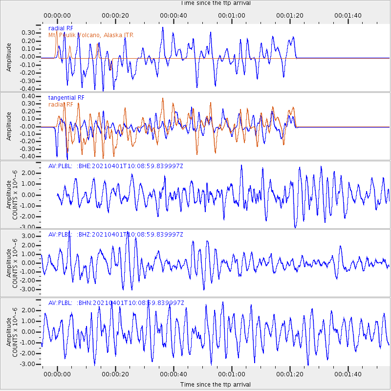
PLBL Mt. Peulik Volcano, Alaska - Earthquake Result Viewer
*The percent match for this event was below the threshold and hence no stack was calculated.
| Earthquake location: |
Kermadec Islands, New Zealand |
| Earthquake latitude/longitude: |
-30.0/-177.7 |
| Earthquake time(UTC): |
2021/04/01 (091) 09:56:36 GMT |
| Earthquake Depth: |
10 km |
| Earthquake Magnitude: |
6.3 Mww |
| Earthquake Catalog/Contributor: |
NEIC PDE/us |
|
| Network: |
AV Alaska Volcano Observatory |
| Station: |
PLBL Mt. Peulik Volcano, Alaska |
| Lat/Lon: |
57.70 N/156.82 W |
| Elevation: |
461 m |
|
| Distance: |
89.1 deg |
| Az: |
11.028 deg |
| Baz: |
198.006 deg |
| Ray Param: |
$rayparam |
*The percent match for this event was below the threshold and hence was not used in the summary stack. |
|
| Radial Match: |
70.26485 % |
| Radial Bump: |
400 |
| Transverse Match: |
62.29245 % |
| Transverse Bump: |
400 |
| SOD ConfigId: |
24334971 |
| Insert Time: |
2021-04-15 10:02:26.756 +0000 |
| GWidth: |
2.5 |
| Max Bumps: |
400 |
| Tol: |
0.001 |
|
Signal To Noise
| Channel | StoN | STA | LTA |
| AV:PLBL: :BHZ:20210401T10:08:59.839997Z | 2.5742202 | 1.3698889E-6 | 5.3215683E-7 |
| AV:PLBL: :BHN:20210401T10:08:59.839997Z | 1.3518125 | 1.095482E-6 | 8.103802E-7 |
| AV:PLBL: :BHE:20210401T10:08:59.839997Z | 1.0663191 | 7.476545E-7 | 7.0115453E-7 |
| Arrivals |
| Ps | |
| PpPs | |
| PsPs/PpSs | |


