You are here: Home > Network List > GS - US Geological Survey Networks Stations List
> Station KAN10 Keim Farm > Earthquake Result Viewer
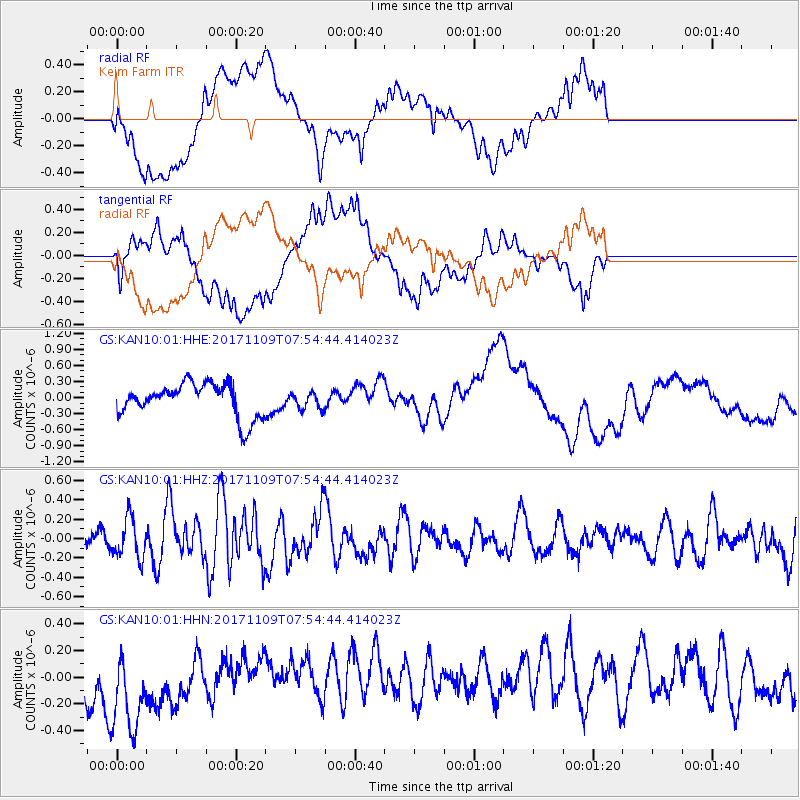
KAN10 Keim Farm - Earthquake Result Viewer
*The percent match for this event was below the threshold and hence no stack was calculated.
| Earthquake location: |
Southeast Of Honshu, Japan |
| Earthquake latitude/longitude: |
32.5/141.4 |
| Earthquake time(UTC): |
2017/11/09 (313) 07:42:12 GMT |
| Earthquake Depth: |
20 km |
| Earthquake Magnitude: |
6.0 Mww |
| Earthquake Catalog/Contributor: |
NEIC PDE/us |
|
| Network: |
GS US Geological Survey Networks |
| Station: |
KAN10 Keim Farm |
| Lat/Lon: |
37.12 N/98.10 W |
| Elevation: |
417 m |
|
| Distance: |
91.2 deg |
| Az: |
43.561 deg |
| Baz: |
313.258 deg |
| Ray Param: |
$rayparam |
*The percent match for this event was below the threshold and hence was not used in the summary stack. |
|
| Radial Match: |
29.035149 % |
| Radial Bump: |
400 |
| Transverse Match: |
33.689888 % |
| Transverse Bump: |
400 |
| SOD ConfigId: |
2429771 |
| Insert Time: |
2017-11-23 07:43:28.032 +0000 |
| GWidth: |
2.5 |
| Max Bumps: |
400 |
| Tol: |
0.001 |
|
Signal To Noise
| Channel | StoN | STA | LTA |
| GS:KAN10:01:HHZ:20171109T07:54:44.414023Z | 2.017574 | 2.0716371E-7 | 1.026796E-7 |
| GS:KAN10:01:HHN:20171109T07:54:44.414023Z | 1.9823512 | 3.9764777E-7 | 2.0059402E-7 |
| GS:KAN10:01:HHE:20171109T07:54:44.414023Z | 0.4743619 | 1.479565E-7 | 3.1190635E-7 |
| Arrivals |
| Ps | |
| PpPs | |
| PsPs/PpSs | |


