You are here: Home > Network List > GS - US Geological Survey Networks Stations List
> Station MCA04 MCA04, Monte Cristo Range, NV > Earthquake Result Viewer
MCA04 MCA04, Monte Cristo Range, NV - Earthquake Result Viewer
| Earthquake location: |
Kermadec Islands, New Zealand |
| Earthquake latitude/longitude: |
-30.0/-177.7 |
| Earthquake time(UTC): |
2021/04/01 (091) 09:56:36 GMT |
| Earthquake Depth: |
10 km |
| Earthquake Magnitude: |
6.3 Mww |
| Earthquake Catalog/Contributor: |
NEIC PDE/us |
|
| Network: |
GS US Geological Survey Networks |
| Station: |
MCA04 MCA04, Monte Cristo Range, NV |
| Lat/Lon: |
38.08 N/117.71 W |
| Elevation: |
1662 m |
|
| Distance: |
87.9 deg |
| Az: |
43.141 deg |
| Baz: |
228.746 deg |
| Ray Param: |
0.04301446 |
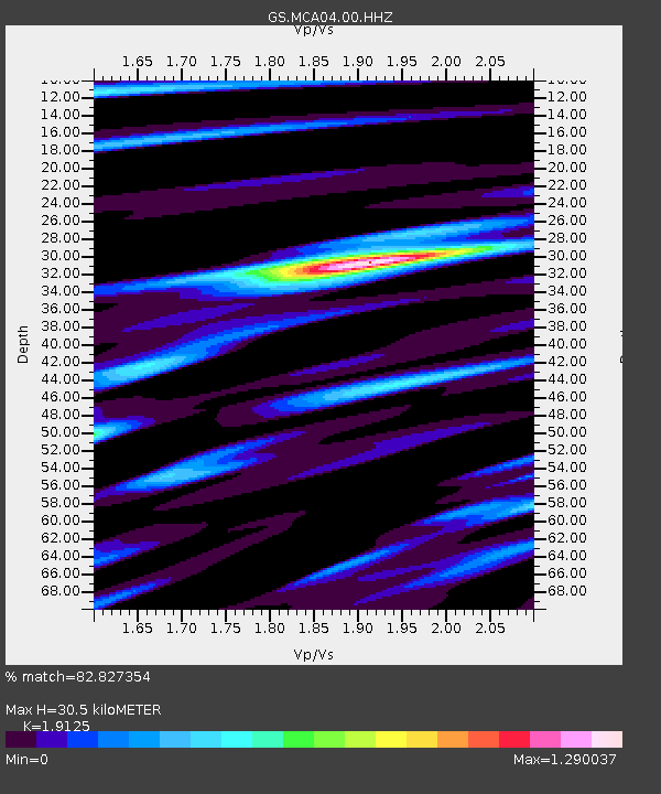
| Estimated Moho Depth: |
30.5 km |
| Estimated Crust Vp/Vs: |
1.91 |
| Assumed Crust Vp: |
6.276 km/s |
| Estimated Crust Vs: |
3.281 km/s |
| Estimated Crust Poisson's Ratio: |
0.31 |
|
| Radial Match: |
82.827354 % |
| Radial Bump: |
302 |
| Transverse Match: |
79.4775 % |
| Transverse Bump: |
223 |
| SOD ConfigId: |
24334971 |
| Insert Time: |
2021-04-15 10:08:05.616 +0000 |
| GWidth: |
2.5 |
| Max Bumps: |
400 |
| Tol: |
0.001 |
|

Signal To Noise
| Channel | StoN | STA | LTA |
| GS:MCA04:00:HHZ:20210401T10:08:54.045014Z | 3.6030977 | 3.6443322E-7 | 1.01144416E-7 |
| GS:MCA04:00:HH1:20210401T10:08:54.045014Z | 0.7759257 | 1.0822786E-7 | 1.3948225E-7 |
| GS:MCA04:00:HH2:20210401T10:08:54.045014Z | 1.1315941 | 1.8176218E-7 | 1.606249E-7 |
| Arrivals |
| Ps | 4.5 SECOND |
| PpPs | 14 SECOND |
| PsPs/PpSs | 18 SECOND |


