You are here: Home > Network List > TA - USArray Transportable Network (new EarthScope stations) Stations List
> Station I17K Unalakleet, AK, USA > Earthquake Result Viewer
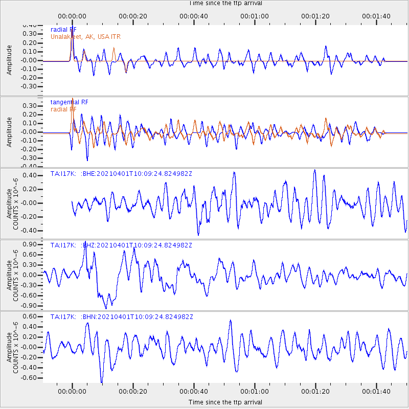
I17K Unalakleet, AK, USA - Earthquake Result Viewer
*The percent match for this event was below the threshold and hence no stack was calculated.
| Earthquake location: |
Kermadec Islands, New Zealand |
| Earthquake latitude/longitude: |
-30.0/-177.7 |
| Earthquake time(UTC): |
2021/04/01 (091) 09:56:36 GMT |
| Earthquake Depth: |
10 km |
| Earthquake Magnitude: |
6.3 Mww |
| Earthquake Catalog/Contributor: |
NEIC PDE/us |
|
| Network: |
TA USArray Transportable Network (new EarthScope stations) |
| Station: |
I17K Unalakleet, AK, USA |
| Lat/Lon: |
63.89 N/160.70 W |
| Elevation: |
105 m |
|
| Distance: |
94.5 deg |
| Az: |
7.455 deg |
| Baz: |
194.737 deg |
| Ray Param: |
$rayparam |
*The percent match for this event was below the threshold and hence was not used in the summary stack. |
|
| Radial Match: |
65.31218 % |
| Radial Bump: |
400 |
| Transverse Match: |
75.77463 % |
| Transverse Bump: |
400 |
| SOD ConfigId: |
24334971 |
| Insert Time: |
2021-04-15 10:12:05.558 +0000 |
| GWidth: |
2.5 |
| Max Bumps: |
400 |
| Tol: |
0.001 |
|
Signal To Noise
| Channel | StoN | STA | LTA |
| TA:I17K: :BHZ:20210401T10:09:24.824982Z | 3.028932 | 3.6791883E-7 | 1.2146816E-7 |
| TA:I17K: :BHN:20210401T10:09:24.824982Z | 1.2739029 | 1.6344892E-7 | 1.2830563E-7 |
| TA:I17K: :BHE:20210401T10:09:24.824982Z | 1.7721889 | 1.474514E-7 | 8.320298E-8 |
| Arrivals |
| Ps | |
| PpPs | |
| PsPs/PpSs | |


