You are here: Home > Network List > TA - USArray Transportable Network (new EarthScope stations) Stations List
> Station O17K Koliganek, Bristol Bay, AK, USA > Earthquake Result Viewer
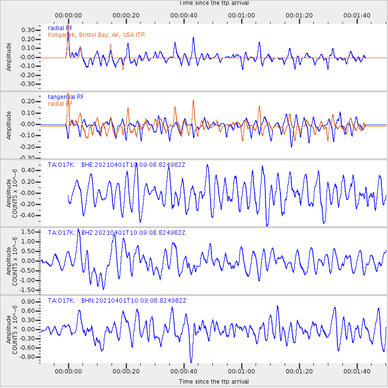
O17K Koliganek, Bristol Bay, AK, USA - Earthquake Result Viewer
*The percent match for this event was below the threshold and hence no stack was calculated.
| Earthquake location: |
Kermadec Islands, New Zealand |
| Earthquake latitude/longitude: |
-30.0/-177.7 |
| Earthquake time(UTC): |
2021/04/01 (091) 09:56:36 GMT |
| Earthquake Depth: |
10 km |
| Earthquake Magnitude: |
6.3 Mww |
| Earthquake Catalog/Contributor: |
NEIC PDE/us |
|
| Network: |
TA USArray Transportable Network (new EarthScope stations) |
| Station: |
O17K Koliganek, Bristol Bay, AK, USA |
| Lat/Lon: |
59.77 N/157.09 W |
| Elevation: |
156 m |
|
| Distance: |
91.0 deg |
| Az: |
10.253 deg |
| Baz: |
197.773 deg |
| Ray Param: |
$rayparam |
*The percent match for this event was below the threshold and hence was not used in the summary stack. |
|
| Radial Match: |
67.58453 % |
| Radial Bump: |
400 |
| Transverse Match: |
56.677303 % |
| Transverse Bump: |
400 |
| SOD ConfigId: |
24334971 |
| Insert Time: |
2021-04-15 10:12:33.609 +0000 |
| GWidth: |
2.5 |
| Max Bumps: |
400 |
| Tol: |
0.001 |
|
Signal To Noise
| Channel | StoN | STA | LTA |
| TA:O17K: :BHZ:20210401T10:09:08.824982Z | 4.8600583 | 7.348755E-7 | 1.5120715E-7 |
| TA:O17K: :BHN:20210401T10:09:08.824982Z | 1.8375082 | 2.9071165E-7 | 1.5820972E-7 |
| TA:O17K: :BHE:20210401T10:09:08.824982Z | 0.80618495 | 1.7610199E-7 | 2.1843869E-7 |
| Arrivals |
| Ps | |
| PpPs | |
| PsPs/PpSs | |


