You are here: Home > Network List > TA - USArray Transportable Network (new EarthScope stations) Stations List
> Station P33M Teslin, Yukon, CA > Earthquake Result Viewer
P33M Teslin, Yukon, CA - Earthquake Result Viewer
| Earthquake location: |
Kermadec Islands, New Zealand |
| Earthquake latitude/longitude: |
-30.0/-177.7 |
| Earthquake time(UTC): |
2021/04/01 (091) 09:56:36 GMT |
| Earthquake Depth: |
10 km |
| Earthquake Magnitude: |
6.3 Mww |
| Earthquake Catalog/Contributor: |
NEIC PDE/us |
|
| Network: |
TA USArray Transportable Network (new EarthScope stations) |
| Station: |
P33M Teslin, Yukon, CA |
| Lat/Lon: |
60.21 N/132.82 W |
| Elevation: |
1066 m |
|
| Distance: |
97.1 deg |
| Az: |
20.794 deg |
| Baz: |
218.09 deg |
| Ray Param: |
0.04031882 |
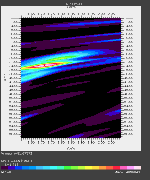
| Estimated Moho Depth: |
33.5 km |
| Estimated Crust Vp/Vs: |
1.72 |
| Assumed Crust Vp: |
6.419 km/s |
| Estimated Crust Vs: |
3.743 km/s |
| Estimated Crust Poisson's Ratio: |
0.24 |
|
| Radial Match: |
81.67572 % |
| Radial Bump: |
400 |
| Transverse Match: |
61.073765 % |
| Transverse Bump: |
398 |
| SOD ConfigId: |
24334971 |
| Insert Time: |
2021-04-15 10:12:38.651 +0000 |
| GWidth: |
2.5 |
| Max Bumps: |
400 |
| Tol: |
0.001 |
|

Signal To Noise
| Channel | StoN | STA | LTA |
| TA:P33M: :BHZ:20210401T10:09:36.550019Z | 1.2944014 | 3.6121884E-7 | 2.7906245E-7 |
| TA:P33M: :BHN:20210401T10:09:36.550019Z | 1.6222411 | 3.587891E-7 | 2.2116879E-7 |
| TA:P33M: :BHE:20210401T10:09:36.550019Z | 2.8158917 | 3.1713333E-7 | 1.126227E-7 |
| Arrivals |
| Ps | 3.8 SECOND |
| PpPs | 14 SECOND |
| PsPs/PpSs | 18 SECOND |


