You are here: Home > Network List > US - United States National Seismic Network Stations List
> Station DUG Dugway, Tooele County, Utah, USA > Earthquake Result Viewer
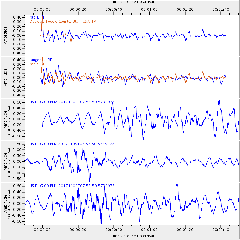
DUG Dugway, Tooele County, Utah, USA - Earthquake Result Viewer
*The percent match for this event was below the threshold and hence no stack was calculated.
| Earthquake location: |
Southeast Of Honshu, Japan |
| Earthquake latitude/longitude: |
32.5/141.4 |
| Earthquake time(UTC): |
2017/11/09 (313) 07:42:12 GMT |
| Earthquake Depth: |
20 km |
| Earthquake Magnitude: |
6.0 Mww |
| Earthquake Catalog/Contributor: |
NEIC PDE/us |
|
| Network: |
US United States National Seismic Network |
| Station: |
DUG Dugway, Tooele County, Utah, USA |
| Lat/Lon: |
40.19 N/112.81 W |
| Elevation: |
1477 m |
|
| Distance: |
80.3 deg |
| Az: |
48.414 deg |
| Baz: |
304.43 deg |
| Ray Param: |
$rayparam |
*The percent match for this event was below the threshold and hence was not used in the summary stack. |
|
| Radial Match: |
64.398224 % |
| Radial Bump: |
400 |
| Transverse Match: |
67.54689 % |
| Transverse Bump: |
400 |
| SOD ConfigId: |
2429771 |
| Insert Time: |
2017-11-23 07:46:04.964 +0000 |
| GWidth: |
2.5 |
| Max Bumps: |
400 |
| Tol: |
0.001 |
|
Signal To Noise
| Channel | StoN | STA | LTA |
| US:DUG:00:BHZ:20171109T07:53:50.573997Z | 1.9204729 | 3.4773743E-7 | 1.8106866E-7 |
| US:DUG:00:BH1:20171109T07:53:50.573997Z | 1.2913579 | 1.8538655E-7 | 1.435594E-7 |
| US:DUG:00:BH2:20171109T07:53:50.573997Z | 1.3095083 | 1.7508788E-7 | 1.3370504E-7 |
| Arrivals |
| Ps | |
| PpPs | |
| PsPs/PpSs | |


