You are here: Home > Network List > AV - Alaska Volcano Observatory Stations List
> Station SPCR Ckakachatna River, Mount Spurr, Alaska > Earthquake Result Viewer
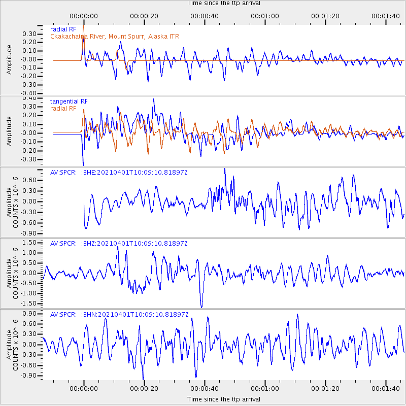
SPCR Ckakachatna River, Mount Spurr, Alaska - Earthquake Result Viewer
*The percent match for this event was below the threshold and hence no stack was calculated.
| Earthquake location: |
Kermadec Islands Region |
| Earthquake latitude/longitude: |
-30.1/-176.4 |
| Earthquake time(UTC): |
2021/04/01 (091) 09:56:40 GMT |
| Earthquake Depth: |
104 km |
| Earthquake Magnitude: |
6.6 Mi |
| Earthquake Catalog/Contributor: |
NEIC PDE/at |
|
| Network: |
AV Alaska Volcano Observatory |
| Station: |
SPCR Ckakachatna River, Mount Spurr, Alaska |
| Lat/Lon: |
61.20 N/152.21 W |
| Elevation: |
984 m |
|
| Distance: |
93.1 deg |
| Az: |
11.462 deg |
| Baz: |
200.832 deg |
| Ray Param: |
$rayparam |
*The percent match for this event was below the threshold and hence was not used in the summary stack. |
|
| Radial Match: |
55.389038 % |
| Radial Bump: |
400 |
| Transverse Match: |
62.90889 % |
| Transverse Bump: |
400 |
| SOD ConfigId: |
24334971 |
| Insert Time: |
2021-04-15 10:19:16.649 +0000 |
| GWidth: |
2.5 |
| Max Bumps: |
400 |
| Tol: |
0.001 |
|
Signal To Noise
| Channel | StoN | STA | LTA |
| AV:SPCR: :BHZ:20210401T10:09:10.81897Z | 1.2746353 | 1.6534398E-7 | 1.2971864E-7 |
| AV:SPCR: :BHN:20210401T10:09:10.81897Z | 1.9825845 | 3.2736583E-7 | 1.6512075E-7 |
| AV:SPCR: :BHE:20210401T10:09:10.81897Z | 0.46193022 | 1.3037881E-7 | 2.8224787E-7 |
| Arrivals |
| Ps | |
| PpPs | |
| PsPs/PpSs | |


