You are here: Home > Network List > NN - Western Great Basin/Eastern Sierra Nevada Stations List
> Station TBRD Thunderbird Lodge, Lake Tahoe, NV > Earthquake Result Viewer
TBRD Thunderbird Lodge, Lake Tahoe, NV - Earthquake Result Viewer
| Earthquake location: |
Kermadec Islands Region |
| Earthquake latitude/longitude: |
-30.1/-176.4 |
| Earthquake time(UTC): |
2021/04/01 (091) 09:56:40 GMT |
| Earthquake Depth: |
104 km |
| Earthquake Magnitude: |
6.6 Mi |
| Earthquake Catalog/Contributor: |
NEIC PDE/at |
|
| Network: |
NN Western Great Basin/Eastern Sierra Nevada |
| Station: |
TBRD Thunderbird Lodge, Lake Tahoe, NV |
| Lat/Lon: |
39.17 N/119.93 W |
| Elevation: |
1952 m |
|
| Distance: |
86.7 deg |
| Az: |
40.471 deg |
| Baz: |
226.354 deg |
| Ray Param: |
0.04366841 |
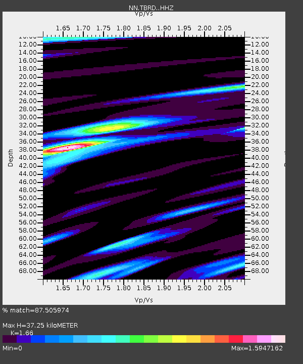
| Estimated Moho Depth: |
37.25 km |
| Estimated Crust Vp/Vs: |
1.66 |
| Assumed Crust Vp: |
6.279 km/s |
| Estimated Crust Vs: |
3.782 km/s |
| Estimated Crust Poisson's Ratio: |
0.22 |
|
| Radial Match: |
87.505974 % |
| Radial Bump: |
339 |
| Transverse Match: |
76.94398 % |
| Transverse Bump: |
400 |
| SOD ConfigId: |
24334971 |
| Insert Time: |
2021-04-15 10:24:48.140 +0000 |
| GWidth: |
2.5 |
| Max Bumps: |
400 |
| Tol: |
0.001 |
|

Signal To Noise
| Channel | StoN | STA | LTA |
| NN:TBRD: :HHZ:20210401T10:08:40.867981Z | 0.82951486 | 1.2614777E-7 | 1.5207415E-7 |
| NN:TBRD: :HHN:20210401T10:08:40.867981Z | 0.48920357 | 9.521631E-8 | 1.9463533E-7 |
| NN:TBRD: :HHE:20210401T10:08:40.867981Z | 1.0543276 | 1.4278665E-7 | 1.354291E-7 |
| Arrivals |
| Ps | 4.0 SECOND |
| PpPs | 15 SECOND |
| PsPs/PpSs | 19 SECOND |


