You are here: Home > Network List > UU - University of Utah Regional Network Stations List
> Station FOR4 Blundell West, UT, USA > Earthquake Result Viewer
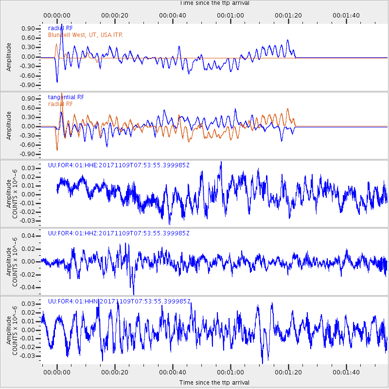
FOR4 Blundell West, UT, USA - Earthquake Result Viewer
*The percent match for this event was below the threshold and hence no stack was calculated.
| Earthquake location: |
Southeast Of Honshu, Japan |
| Earthquake latitude/longitude: |
32.5/141.4 |
| Earthquake time(UTC): |
2017/11/09 (313) 07:42:12 GMT |
| Earthquake Depth: |
20 km |
| Earthquake Magnitude: |
6.0 Mww |
| Earthquake Catalog/Contributor: |
NEIC PDE/us |
|
| Network: |
UU University of Utah Regional Network |
| Station: |
FOR4 Blundell West, UT, USA |
| Lat/Lon: |
38.50 N/112.90 W |
| Elevation: |
1657 m |
|
| Distance: |
81.2 deg |
| Az: |
49.866 deg |
| Baz: |
304.611 deg |
| Ray Param: |
$rayparam |
*The percent match for this event was below the threshold and hence was not used in the summary stack. |
|
| Radial Match: |
64.43481 % |
| Radial Bump: |
400 |
| Transverse Match: |
52.886234 % |
| Transverse Bump: |
400 |
| SOD ConfigId: |
2429771 |
| Insert Time: |
2017-11-23 07:46:36.725 +0000 |
| GWidth: |
2.5 |
| Max Bumps: |
400 |
| Tol: |
0.001 |
|
Signal To Noise
| Channel | StoN | STA | LTA |
| UU:FOR4:01:HHZ:20171109T07:53:55.399985Z | 1.5581275 | 6.7770043E-9 | 4.349454E-9 |
| UU:FOR4:01:HHN:20171109T07:53:55.399985Z | 1.2863816 | 1.4101386E-8 | 1.0962054E-8 |
| UU:FOR4:01:HHE:20171109T07:53:55.399985Z | 2.3621376 | 1.6881874E-8 | 7.146863E-9 |
| Arrivals |
| Ps | |
| PpPs | |
| PsPs/PpSs | |


