You are here: Home > Network List > TA - USArray Transportable Network (new EarthScope stations) Stations List
> Station P33M Teslin, Yukon, CA > Earthquake Result Viewer
P33M Teslin, Yukon, CA - Earthquake Result Viewer
| Earthquake location: |
Kermadec Islands Region |
| Earthquake latitude/longitude: |
-30.1/-176.4 |
| Earthquake time(UTC): |
2021/04/01 (091) 09:56:40 GMT |
| Earthquake Depth: |
104 km |
| Earthquake Magnitude: |
6.6 Mi |
| Earthquake Catalog/Contributor: |
NEIC PDE/at |
|
| Network: |
TA USArray Transportable Network (new EarthScope stations) |
| Station: |
P33M Teslin, Yukon, CA |
| Lat/Lon: |
60.21 N/132.82 W |
| Elevation: |
1066 m |
|
| Distance: |
96.8 deg |
| Az: |
20.285 deg |
| Baz: |
216.992 deg |
| Ray Param: |
0.040319603 |
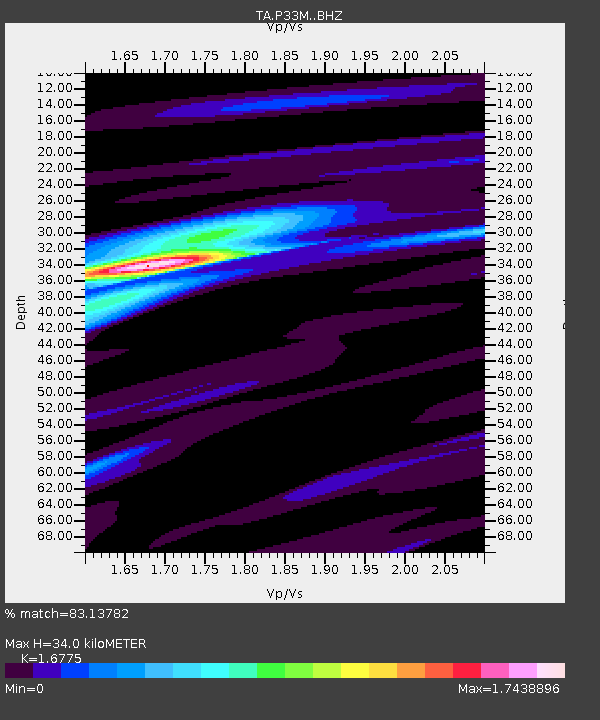
| Estimated Moho Depth: |
34.0 km |
| Estimated Crust Vp/Vs: |
1.68 |
| Assumed Crust Vp: |
6.419 km/s |
| Estimated Crust Vs: |
3.827 km/s |
| Estimated Crust Poisson's Ratio: |
0.22 |
|
| Radial Match: |
83.13782 % |
| Radial Bump: |
400 |
| Transverse Match: |
55.248802 % |
| Transverse Bump: |
358 |
| SOD ConfigId: |
24334971 |
| Insert Time: |
2021-04-15 10:26:57.351 +0000 |
| GWidth: |
2.5 |
| Max Bumps: |
400 |
| Tol: |
0.001 |
|

Signal To Noise
| Channel | StoN | STA | LTA |
| TA:P33M: :BHZ:20210401T10:09:27.775024Z | 1.7852995 | 3.5575295E-7 | 1.9926794E-7 |
| TA:P33M: :BHN:20210401T10:09:27.775024Z | 1.0878297 | 2.0514992E-7 | 1.8858643E-7 |
| TA:P33M: :BHE:20210401T10:09:27.775024Z | 0.80833536 | 1.15131066E-7 | 1.4242983E-7 |
| Arrivals |
| Ps | 3.7 SECOND |
| PpPs | 14 SECOND |
| PsPs/PpSs | 18 SECOND |


