You are here: Home > Network List > GS - US Geological Survey Networks Stations List
> Station OK051 E0350 and S34600 Roads, Ralston, OK > Earthquake Result Viewer
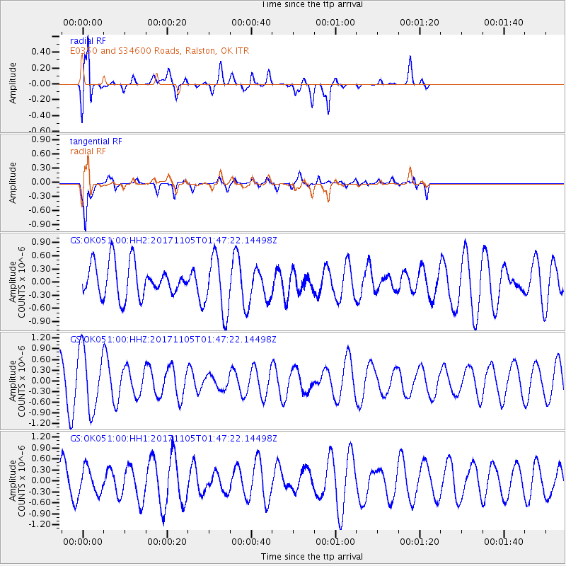
OK051 E0350 and S34600 Roads, Ralston, OK - Earthquake Result Viewer
*The percent match for this event was below the threshold and hence no stack was calculated.
| Earthquake location: |
Fiji Islands Region |
| Earthquake latitude/longitude: |
-18.6/-177.7 |
| Earthquake time(UTC): |
2017/11/05 (309) 01:35:28 GMT |
| Earthquake Depth: |
483 km |
| Earthquake Magnitude: |
5.5 Mww |
| Earthquake Catalog/Contributor: |
NEIC PDE/us |
|
| Network: |
GS US Geological Survey Networks |
| Station: |
OK051 E0350 and S34600 Roads, Ralston, OK |
| Lat/Lon: |
36.51 N/96.84 W |
| Elevation: |
263 m |
|
| Distance: |
93.9 deg |
| Az: |
52.883 deg |
| Baz: |
249.78 deg |
| Ray Param: |
$rayparam |
*The percent match for this event was below the threshold and hence was not used in the summary stack. |
|
| Radial Match: |
75.508286 % |
| Radial Bump: |
400 |
| Transverse Match: |
68.46365 % |
| Transverse Bump: |
390 |
| SOD ConfigId: |
2429771 |
| Insert Time: |
2017-11-24 01:32:50.908 +0000 |
| GWidth: |
2.5 |
| Max Bumps: |
400 |
| Tol: |
0.001 |
|
Signal To Noise
| Channel | StoN | STA | LTA |
| GS:OK051:00:HHZ:20171105T01:47:22.14498Z | 2.2838 | 8.6250753E-7 | 3.7766335E-7 |
| GS:OK051:00:HH1:20171105T01:47:22.14498Z | 0.89881176 | 3.4410488E-7 | 3.828442E-7 |
| GS:OK051:00:HH2:20171105T01:47:22.14498Z | 1.7415156 | 6.52143E-7 | 3.7446864E-7 |
| Arrivals |
| Ps | |
| PpPs | |
| PsPs/PpSs | |


