You are here: Home > Network List > AV - Alaska Volcano Observatory Stations List
> Station SPCR Ckakachatna River, Mount Spurr, Alaska > Earthquake Result Viewer
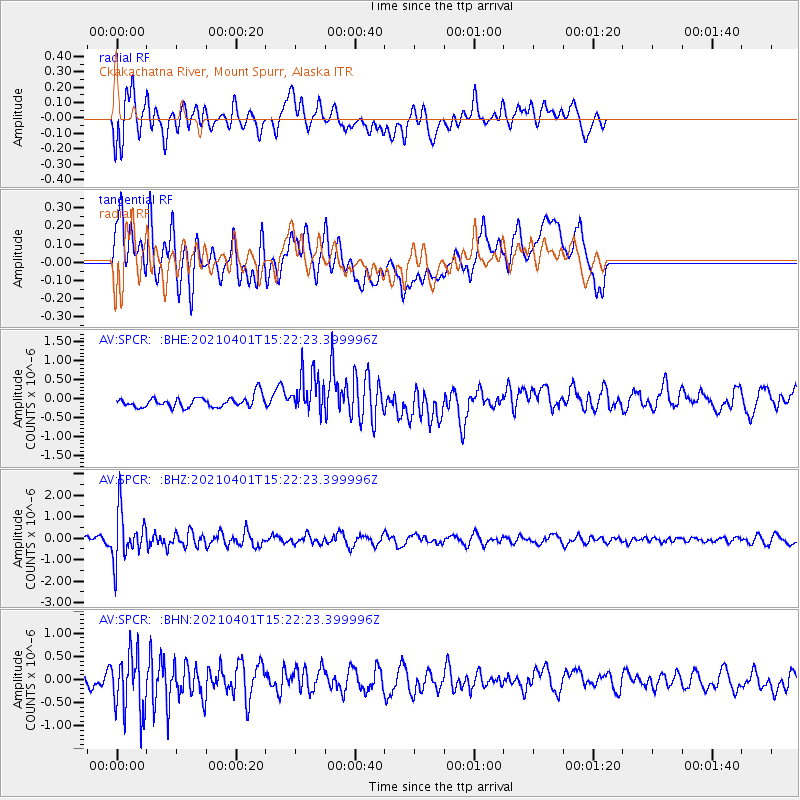
SPCR Ckakachatna River, Mount Spurr, Alaska - Earthquake Result Viewer
*The percent match for this event was below the threshold and hence no stack was calculated.
| Earthquake location: |
Fiji Islands Region |
| Earthquake latitude/longitude: |
-21.9/-179.3 |
| Earthquake time(UTC): |
2021/04/01 (091) 15:11:18 GMT |
| Earthquake Depth: |
598 km |
| Earthquake Magnitude: |
6.0 mww |
| Earthquake Catalog/Contributor: |
NEIC PDE/us |
|
| Network: |
AV Alaska Volcano Observatory |
| Station: |
SPCR Ckakachatna River, Mount Spurr, Alaska |
| Lat/Lon: |
61.20 N/152.21 W |
| Elevation: |
984 m |
|
| Distance: |
85.6 deg |
| Az: |
12.796 deg |
| Baz: |
205.141 deg |
| Ray Param: |
$rayparam |
*The percent match for this event was below the threshold and hence was not used in the summary stack. |
|
| Radial Match: |
59.355797 % |
| Radial Bump: |
400 |
| Transverse Match: |
51.446644 % |
| Transverse Bump: |
400 |
| SOD ConfigId: |
24334971 |
| Insert Time: |
2021-04-15 15:18:54.879 +0000 |
| GWidth: |
2.5 |
| Max Bumps: |
400 |
| Tol: |
0.001 |
|
Signal To Noise
| Channel | StoN | STA | LTA |
| AV:SPCR: :BHZ:20210401T15:22:23.399996Z | 5.7095213 | 1.1427019E-6 | 2.001397E-7 |
| AV:SPCR: :BHN:20210401T15:22:23.399996Z | 2.9300768 | 6.425354E-7 | 2.1928959E-7 |
| AV:SPCR: :BHE:20210401T15:22:23.399996Z | 3.7829258 | 5.426738E-7 | 1.4345345E-7 |
| Arrivals |
| Ps | |
| PpPs | |
| PsPs/PpSs | |


