You are here: Home > Network List > IU - Global Seismograph Network (GSN - IRIS/USGS) Stations List
> Station PMG Port Moresby, New Guinea > Earthquake Result Viewer
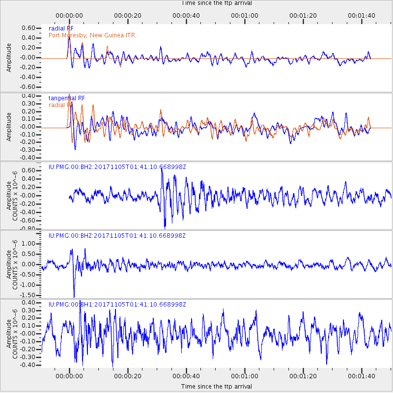
PMG Port Moresby, New Guinea - Earthquake Result Viewer
*The percent match for this event was below the threshold and hence no stack was calculated.
| Earthquake location: |
Fiji Islands Region |
| Earthquake latitude/longitude: |
-18.6/-177.7 |
| Earthquake time(UTC): |
2017/11/05 (309) 01:35:28 GMT |
| Earthquake Depth: |
483 km |
| Earthquake Magnitude: |
5.5 Mww |
| Earthquake Catalog/Contributor: |
NEIC PDE/us |
|
| Network: |
IU Global Seismograph Network (GSN - IRIS/USGS) |
| Station: |
PMG Port Moresby, New Guinea |
| Lat/Lon: |
9.40 S/147.16 E |
| Elevation: |
90 m |
|
| Distance: |
35.2 deg |
| Az: |
280.261 deg |
| Baz: |
109.0 deg |
| Ray Param: |
$rayparam |
*The percent match for this event was below the threshold and hence was not used in the summary stack. |
|
| Radial Match: |
64.58438 % |
| Radial Bump: |
400 |
| Transverse Match: |
61.664616 % |
| Transverse Bump: |
400 |
| SOD ConfigId: |
2429771 |
| Insert Time: |
2017-11-24 01:33:26.529 +0000 |
| GWidth: |
2.5 |
| Max Bumps: |
400 |
| Tol: |
0.001 |
|
Signal To Noise
| Channel | StoN | STA | LTA |
| IU:PMG:00:BHZ:20171105T01:41:10.668998Z | 4.7099032 | 5.0343647E-7 | 1.0688892E-7 |
| IU:PMG:00:BH1:20171105T01:41:10.668998Z | 1.5751599 | 1.80397E-7 | 1.14526145E-7 |
| IU:PMG:00:BH2:20171105T01:41:10.668998Z | 3.6610177 | 3.1729135E-7 | 8.6667534E-8 |
| Arrivals |
| Ps | |
| PpPs | |
| PsPs/PpSs | |


