You are here: Home > Network List > US - United States National Seismic Network Stations List
> Station AMTX Amarillo, Texas, USA > Earthquake Result Viewer
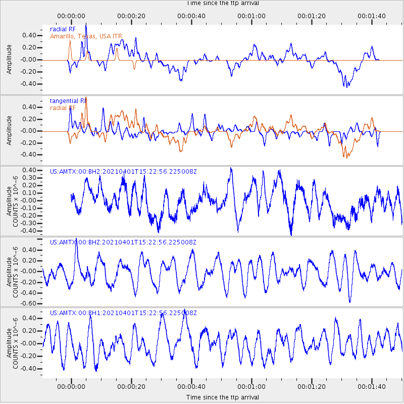
AMTX Amarillo, Texas, USA - Earthquake Result Viewer
*The percent match for this event was below the threshold and hence no stack was calculated.
| Earthquake location: |
Fiji Islands Region |
| Earthquake latitude/longitude: |
-21.9/-179.3 |
| Earthquake time(UTC): |
2021/04/01 (091) 15:11:18 GMT |
| Earthquake Depth: |
598 km |
| Earthquake Magnitude: |
6.0 mww |
| Earthquake Catalog/Contributor: |
NEIC PDE/us |
|
| Network: |
US United States National Seismic Network |
| Station: |
AMTX Amarillo, Texas, USA |
| Lat/Lon: |
34.53 N/101.41 W |
| Elevation: |
1010 m |
|
| Distance: |
92.8 deg |
| Az: |
53.932 deg |
| Baz: |
245.426 deg |
| Ray Param: |
$rayparam |
*The percent match for this event was below the threshold and hence was not used in the summary stack. |
|
| Radial Match: |
51.13433 % |
| Radial Bump: |
400 |
| Transverse Match: |
51.94261 % |
| Transverse Bump: |
400 |
| SOD ConfigId: |
24334971 |
| Insert Time: |
2021-04-15 15:30:08.806 +0000 |
| GWidth: |
2.5 |
| Max Bumps: |
400 |
| Tol: |
0.001 |
|
Signal To Noise
| Channel | StoN | STA | LTA |
| US:AMTX:00:BHZ:20210401T15:22:56.225008Z | 1.588044 | 2.541171E-7 | 1.6001893E-7 |
| US:AMTX:00:BH1:20210401T15:22:56.225008Z | 1.7854613 | 2.3462371E-7 | 1.314079E-7 |
| US:AMTX:00:BH2:20210401T15:22:56.225008Z | 1.8223354 | 2.521803E-7 | 1.3838306E-7 |
| Arrivals |
| Ps | |
| PpPs | |
| PsPs/PpSs | |


