You are here: Home > Network List > US - United States National Seismic Network Stations List
> Station MNTX Cornudas Mountains, Texas, USA > Earthquake Result Viewer
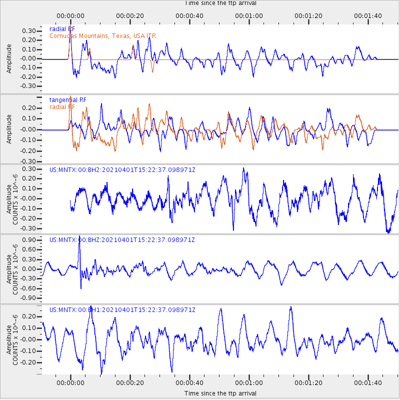
MNTX Cornudas Mountains, Texas, USA - Earthquake Result Viewer
*The percent match for this event was below the threshold and hence no stack was calculated.
| Earthquake location: |
Fiji Islands Region |
| Earthquake latitude/longitude: |
-21.9/-179.3 |
| Earthquake time(UTC): |
2021/04/01 (091) 15:11:18 GMT |
| Earthquake Depth: |
598 km |
| Earthquake Magnitude: |
6.0 mww |
| Earthquake Catalog/Contributor: |
NEIC PDE/us |
|
| Network: |
US United States National Seismic Network |
| Station: |
MNTX Cornudas Mountains, Texas, USA |
| Lat/Lon: |
31.70 N/105.38 W |
| Elevation: |
404 m |
|
| Distance: |
88.6 deg |
| Az: |
55.031 deg |
| Baz: |
243.251 deg |
| Ray Param: |
$rayparam |
*The percent match for this event was below the threshold and hence was not used in the summary stack. |
|
| Radial Match: |
60.903496 % |
| Radial Bump: |
400 |
| Transverse Match: |
51.844162 % |
| Transverse Bump: |
400 |
| SOD ConfigId: |
24334971 |
| Insert Time: |
2021-04-15 15:30:16.741 +0000 |
| GWidth: |
2.5 |
| Max Bumps: |
400 |
| Tol: |
0.001 |
|
Signal To Noise
| Channel | StoN | STA | LTA |
| US:MNTX:00:BHZ:20210401T15:22:37.098971Z | 2.8942664 | 3.105781E-7 | 1.07308054E-7 |
| US:MNTX:00:BH1:20210401T15:22:37.098971Z | 1.5488302 | 1.5385028E-7 | 9.9333214E-8 |
| US:MNTX:00:BH2:20210401T15:22:37.098971Z | 1.595263 | 1.08204E-7 | 6.782831E-8 |
| Arrivals |
| Ps | |
| PpPs | |
| PsPs/PpSs | |


