You are here: Home > Network List > IW - Intermountain West Stations List
> Station DCID1 Drake Creek, Idaho, USA > Earthquake Result Viewer
DCID1 Drake Creek, Idaho, USA - Earthquake Result Viewer
| Earthquake location: |
Kuril Islands |
| Earthquake latitude/longitude: |
46.0/151.5 |
| Earthquake time(UTC): |
2009/04/07 (097) 04:23:33 GMT |
| Earthquake Depth: |
31 km |
| Earthquake Magnitude: |
6.5 MB, 6.8 MS, 6.9 MW, 6.9 MW |
| Earthquake Catalog/Contributor: |
WHDF/NEIC |
|
| Network: |
IW Intermountain West |
| Station: |
DCID1 Drake Creek, Idaho, USA |
| Lat/Lon: |
43.59 N/111.18 W |
| Elevation: |
1871 m |
|
| Distance: |
64.6 deg |
| Az: |
52.929 deg |
| Baz: |
310.107 deg |
| Ray Param: |
0.058776103 |
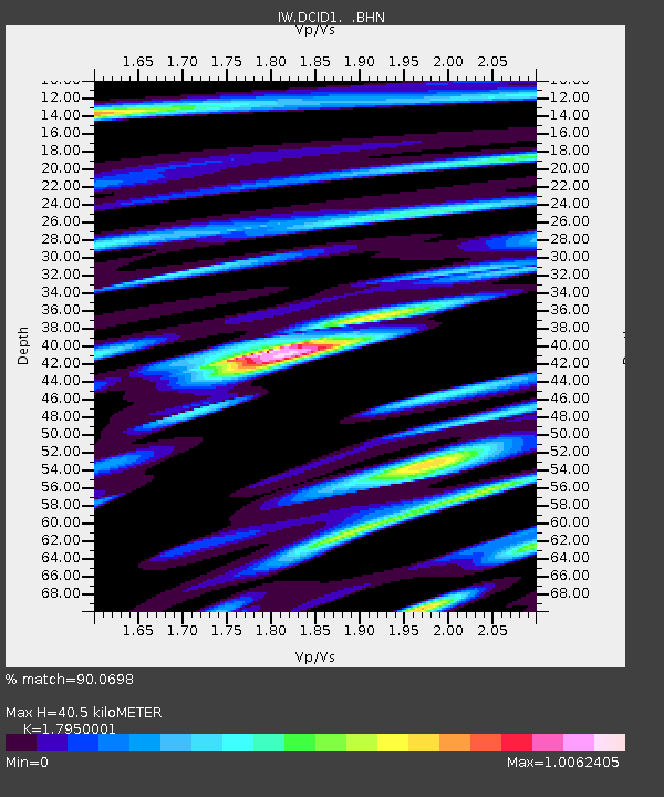
| Estimated Moho Depth: |
40.5 km |
| Estimated Crust Vp/Vs: |
1.80 |
| Assumed Crust Vp: |
6.207 km/s |
| Estimated Crust Vs: |
3.458 km/s |
| Estimated Crust Poisson's Ratio: |
0.27 |
|
| Radial Match: |
90.0698 % |
| Radial Bump: |
400 |
| Transverse Match: |
65.48295 % |
| Transverse Bump: |
400 |
| SOD ConfigId: |
2658 |
| Insert Time: |
2010-03-09 07:07:52.889 +0000 |
| GWidth: |
2.5 |
| Max Bumps: |
400 |
| Tol: |
0.001 |
|

Signal To Noise
| Channel | StoN | STA | LTA |
| IW:DCID1: :BHN:20090407T04:33:36.590002Z | 33.218155 | 3.417279E-6 | 1.0287384E-7 |
| IW:DCID1: :BHE:20090407T04:33:36.590002Z | 6.819491 | 1.1306541E-6 | 1.6579743E-7 |
| IW:DCID1: :BHZ:20090407T04:33:36.590002Z | 5.262277 | 1.1330987E-6 | 2.153248E-7 |
| Arrivals |
| Ps | 5.4 SECOND |
| PpPs | 18 SECOND |
| PsPs/PpSs | 23 SECOND |


