You are here: Home > Network List > G - GEOSCOPE Stations List
> Station CRZF Port Alfred, Crozet, South Indian Ocean > Earthquake Result Viewer
CRZF Port Alfred, Crozet, South Indian Ocean - Earthquake Result Viewer
| Earthquake location: |
East Of South Sandwich Islands |
| Earthquake latitude/longitude: |
-58.0/-7.9 |
| Earthquake time(UTC): |
2021/04/03 (093) 01:16:39 GMT |
| Earthquake Depth: |
10 km |
| Earthquake Magnitude: |
6.4 Mwp |
| Earthquake Catalog/Contributor: |
NEIC PDE/us |
|
| Network: |
G GEOSCOPE |
| Station: |
CRZF Port Alfred, Crozet, South Indian Ocean |
| Lat/Lon: |
46.43 S/51.86 E |
| Elevation: |
140 m |
|
| Distance: |
37.2 deg |
| Az: |
98.538 deg |
| Baz: |
229.622 deg |
| Ray Param: |
0.07630817 |
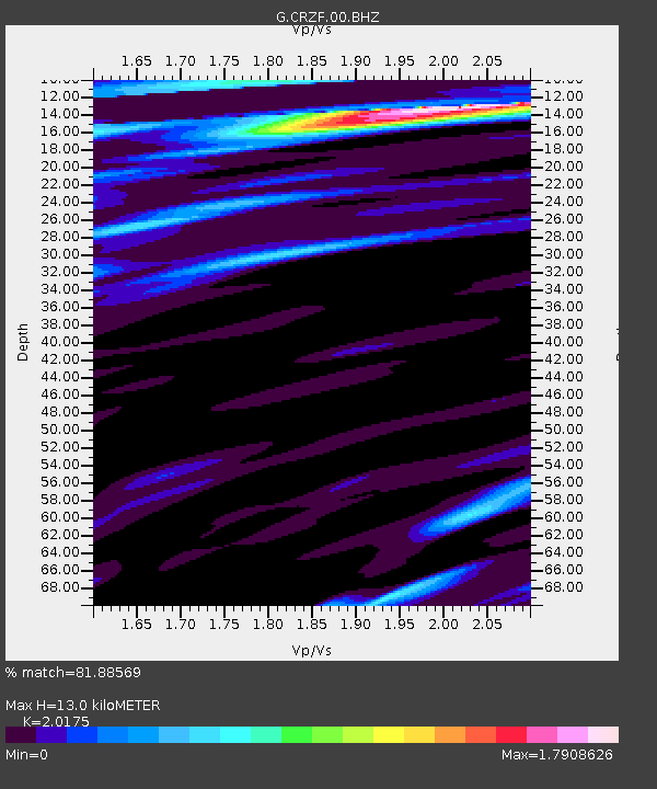
| Estimated Moho Depth: |
13.0 km |
| Estimated Crust Vp/Vs: |
2.02 |
| Assumed Crust Vp: |
4.802 km/s |
| Estimated Crust Vs: |
2.38 km/s |
| Estimated Crust Poisson's Ratio: |
0.34 |
|
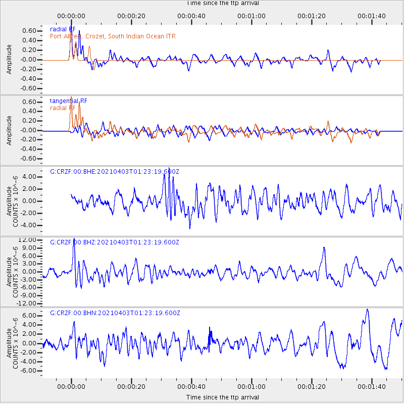
| Radial Match: |
81.88569 % |
| Radial Bump: |
384 |
| Transverse Match: |
67.51291 % |
| Transverse Bump: |
400 |
| SOD ConfigId: |
24334971 |
| Insert Time: |
2021-04-17 01:22:55.691 +0000 |
| GWidth: |
2.5 |
| Max Bumps: |
400 |
| Tol: |
0.001 |
|
Signal To Noise
| Channel | StoN | STA | LTA |
| G:CRZF:00:BHZ:20210403T01:23:19.600Z | 3.9010808 | 4.8153756E-6 | 1.2343696E-6 |
| G:CRZF:00:BHN:20210403T01:23:19.600Z | 1.6880656 | 2.0383593E-6 | 1.2075119E-6 |
| G:CRZF:00:BHE:20210403T01:23:19.600Z | 2.662436 | 2.5470042E-6 | 9.566443E-7 |
| Arrivals |
| Ps | 2.9 SECOND |
| PpPs | 7.9 SECOND |
| PsPs/PpSs | 11 SECOND |


