You are here: Home > Network List > G - GEOSCOPE Stations List
> Station FOMA Nahampoana reservation, Fort Dauphin, Madagascar > Earthquake Result Viewer
FOMA Nahampoana reservation, Fort Dauphin, Madagascar - Earthquake Result Viewer
| Earthquake location: |
East Of South Sandwich Islands |
| Earthquake latitude/longitude: |
-58.0/-7.9 |
| Earthquake time(UTC): |
2021/04/03 (093) 01:16:39 GMT |
| Earthquake Depth: |
10 km |
| Earthquake Magnitude: |
6.4 Mwp |
| Earthquake Catalog/Contributor: |
NEIC PDE/us |
|
| Network: |
G GEOSCOPE |
| Station: |
FOMA Nahampoana reservation, Fort Dauphin, Madagascar |
| Lat/Lon: |
24.98 S/46.98 E |
| Elevation: |
26 m |
|
| Distance: |
50.7 deg |
| Az: |
73.587 deg |
| Baz: |
214.274 deg |
| Ray Param: |
0.06790306 |
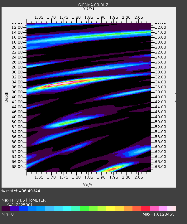
| Estimated Moho Depth: |
34.5 km |
| Estimated Crust Vp/Vs: |
1.73 |
| Assumed Crust Vp: |
6.183 km/s |
| Estimated Crust Vs: |
3.569 km/s |
| Estimated Crust Poisson's Ratio: |
0.25 |
|
| Radial Match: |
86.49644 % |
| Radial Bump: |
400 |
| Transverse Match: |
61.92592 % |
| Transverse Bump: |
400 |
| SOD ConfigId: |
24334971 |
| Insert Time: |
2021-04-17 01:23:01.205 +0000 |
| GWidth: |
2.5 |
| Max Bumps: |
400 |
| Tol: |
0.001 |
|

Signal To Noise
| Channel | StoN | STA | LTA |
| G:FOMA:00:BHZ:20210403T01:25:07.899988Z | 6.128407 | 1.580956E-6 | 2.5797178E-7 |
| G:FOMA:00:BHN:20210403T01:25:07.899988Z | 3.9575484 | 6.180195E-7 | 1.5616222E-7 |
| G:FOMA:00:BHE:20210403T01:25:07.899988Z | 1.6655289 | 3.7881696E-7 | 2.2744545E-7 |
| Arrivals |
| Ps | 4.3 SECOND |
| PpPs | 14 SECOND |
| PsPs/PpSs | 19 SECOND |


