You are here: Home > Network List > G - GEOSCOPE Stations List
> Station MPG Montagne des Peres, French Guyana > Earthquake Result Viewer
MPG Montagne des Peres, French Guyana - Earthquake Result Viewer
| Earthquake location: |
East Of South Sandwich Islands |
| Earthquake latitude/longitude: |
-58.0/-7.9 |
| Earthquake time(UTC): |
2021/04/03 (093) 01:16:39 GMT |
| Earthquake Depth: |
10 km |
| Earthquake Magnitude: |
6.4 Mwp |
| Earthquake Catalog/Contributor: |
NEIC PDE/us |
|
| Network: |
G GEOSCOPE |
| Station: |
MPG Montagne des Peres, French Guyana |
| Lat/Lon: |
5.11 N/52.64 W |
| Elevation: |
147 m |
|
| Distance: |
72.4 deg |
| Az: |
312.608 deg |
| Baz: |
156.816 deg |
| Ray Param: |
0.053664457 |
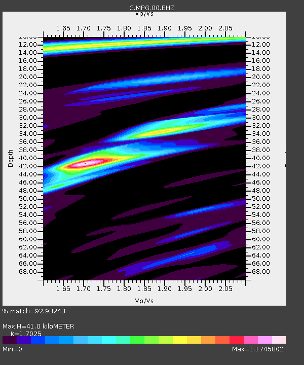
| Estimated Moho Depth: |
41.0 km |
| Estimated Crust Vp/Vs: |
1.70 |
| Assumed Crust Vp: |
6.472 km/s |
| Estimated Crust Vs: |
3.801 km/s |
| Estimated Crust Poisson's Ratio: |
0.24 |
|
| Radial Match: |
92.93243 % |
| Radial Bump: |
400 |
| Transverse Match: |
74.69883 % |
| Transverse Bump: |
400 |
| SOD ConfigId: |
24334971 |
| Insert Time: |
2021-04-17 01:23:02.843 +0000 |
| GWidth: |
2.5 |
| Max Bumps: |
400 |
| Tol: |
0.001 |
|
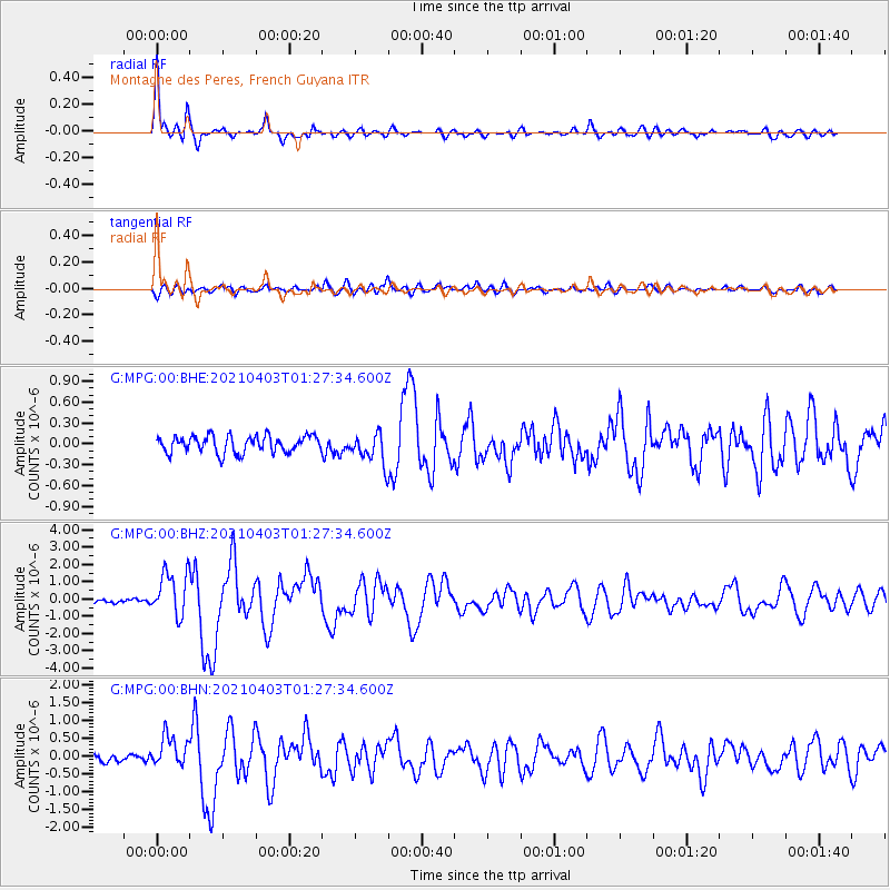
Signal To Noise
| Channel | StoN | STA | LTA |
| G:MPG:00:BHZ:20210403T01:27:34.600Z | 7.8655796 | 1.2987007E-6 | 1.6511189E-7 |
| G:MPG:00:BHN:20210403T01:27:34.600Z | 2.7203517 | 4.2950396E-7 | 1.5788545E-7 |
| G:MPG:00:BHE:20210403T01:27:34.600Z | 1.776746 | 2.1541052E-7 | 1.2123878E-7 |
| Arrivals |
| Ps | 4.6 SECOND |
| PpPs | 16 SECOND |
| PsPs/PpSs | 21 SECOND |


