You are here: Home > Network List > G - GEOSCOPE Stations List
> Station TAM Tamanrasset, Algeria > Earthquake Result Viewer
TAM Tamanrasset, Algeria - Earthquake Result Viewer
| Earthquake location: |
East Of South Sandwich Islands |
| Earthquake latitude/longitude: |
-58.0/-7.9 |
| Earthquake time(UTC): |
2021/04/03 (093) 01:16:39 GMT |
| Earthquake Depth: |
10 km |
| Earthquake Magnitude: |
6.4 Mwp |
| Earthquake Catalog/Contributor: |
NEIC PDE/us |
|
| Network: |
G GEOSCOPE |
| Station: |
TAM Tamanrasset, Algeria |
| Lat/Lon: |
22.79 N/5.53 E |
| Elevation: |
1377 m |
|
| Distance: |
81.2 deg |
| Az: |
12.485 deg |
| Baz: |
187.17 deg |
| Ray Param: |
0.047736418 |
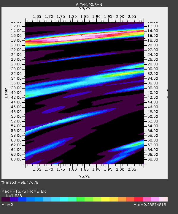
| Estimated Moho Depth: |
15.75 km |
| Estimated Crust Vp/Vs: |
1.84 |
| Assumed Crust Vp: |
6.61 km/s |
| Estimated Crust Vs: |
3.602 km/s |
| Estimated Crust Poisson's Ratio: |
0.29 |
|
| Radial Match: |
96.47678 % |
| Radial Bump: |
343 |
| Transverse Match: |
82.19262 % |
| Transverse Bump: |
400 |
| SOD ConfigId: |
24334971 |
| Insert Time: |
2021-04-17 01:23:07.643 +0000 |
| GWidth: |
2.5 |
| Max Bumps: |
400 |
| Tol: |
0.001 |
|

Signal To Noise
| Channel | StoN | STA | LTA |
| G:TAM:00:BHZ:20210403T01:28:24.100Z | 7.295251 | 5.0940275E-7 | 6.9826626E-8 |
| G:TAM:00:BHN:20210403T01:28:24.100Z | 3.2624018 | 1.5650177E-7 | 4.7971334E-8 |
| G:TAM:00:BHE:20210403T01:28:24.100Z | 1.5387787 | 6.21098E-8 | 4.036305E-8 |
| Arrivals |
| Ps | 2.0 SECOND |
| PpPs | 6.6 SECOND |
| PsPs/PpSs | 8.6 SECOND |


