You are here: Home > Network List > GT - Global Telemetered Seismograph Network (USAF/USGS) Stations List
> Station LPAZ La Paz , Bolivia > Earthquake Result Viewer
LPAZ La Paz , Bolivia - Earthquake Result Viewer
| Earthquake location: |
East Of South Sandwich Islands |
| Earthquake latitude/longitude: |
-58.0/-7.9 |
| Earthquake time(UTC): |
2021/04/03 (093) 01:16:39 GMT |
| Earthquake Depth: |
10 km |
| Earthquake Magnitude: |
6.4 Mwp |
| Earthquake Catalog/Contributor: |
NEIC PDE/us |
|
| Network: |
GT Global Telemetered Seismograph Network (USAF/USGS) |
| Station: |
LPAZ La Paz , Bolivia |
| Lat/Lon: |
16.17 S/68.08 W |
| Elevation: |
4817 m |
|
| Distance: |
60.8 deg |
| Az: |
287.089 deg |
| Baz: |
147.995 deg |
| Ray Param: |
0.061336435 |
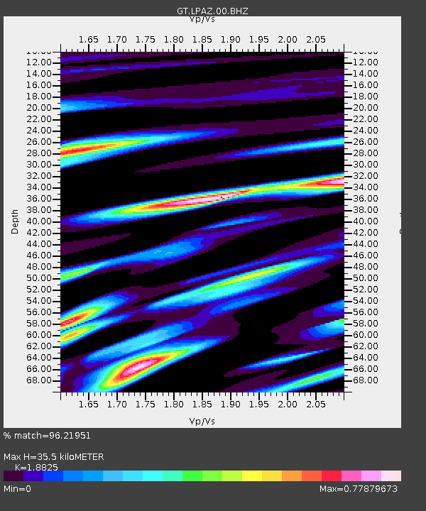
| Estimated Moho Depth: |
35.5 km |
| Estimated Crust Vp/Vs: |
1.88 |
| Assumed Crust Vp: |
6.454 km/s |
| Estimated Crust Vs: |
3.428 km/s |
| Estimated Crust Poisson's Ratio: |
0.30 |
|
| Radial Match: |
96.21951 % |
| Radial Bump: |
400 |
| Transverse Match: |
84.577675 % |
| Transverse Bump: |
400 |
| SOD ConfigId: |
24334971 |
| Insert Time: |
2021-04-17 01:23:25.615 +0000 |
| GWidth: |
2.5 |
| Max Bumps: |
400 |
| Tol: |
0.001 |
|

Signal To Noise
| Channel | StoN | STA | LTA |
| GT:LPAZ:00:BHZ:20210403T01:26:19.698999Z | 10.836017 | 2.5492925E-6 | 2.3526104E-7 |
| GT:LPAZ:00:BHN:20210403T01:26:19.698999Z | 6.2203383 | 8.9323015E-7 | 1.4359831E-7 |
| GT:LPAZ:00:BHE:20210403T01:26:19.698999Z | 9.016403 | 8.138347E-7 | 9.0261565E-8 |
| Arrivals |
| Ps | 5.1 SECOND |
| PpPs | 15 SECOND |
| PsPs/PpSs | 20 SECOND |


