You are here: Home > Network List > II - Global Seismograph Network (GSN - IRIS/IDA) Stations List
> Station ABPO Ambohimpanompo, Madagascar > Earthquake Result Viewer
ABPO Ambohimpanompo, Madagascar - Earthquake Result Viewer

| Earthquake location: |
East Of South Sandwich Islands |
| Earthquake latitude/longitude: |
-58.0/-7.9 |
| Earthquake time(UTC): |
2021/04/03 (093) 01:16:39 GMT |
| Earthquake Depth: |
10 km |
| Earthquake Magnitude: |
6.4 Mwp |
| Earthquake Catalog/Contributor: |
NEIC PDE/us |
|
| Network: |
II Global Seismograph Network (GSN - IRIS/IDA) |
| Station: |
ABPO Ambohimpanompo, Madagascar |
| Lat/Lon: |
19.02 S/47.23 E |
| Elevation: |
1528 m |
|
| Distance: |
55.8 deg |
| Az: |
69.789 deg |
| Baz: |
211.904 deg |
| Ray Param: |
0.06458951 |
| Estimated Moho Depth: |
69.5 km |
| Estimated Crust Vp/Vs: |
2.10 |
| Assumed Crust Vp: |
6.642 km/s |
| Estimated Crust Vs: |
3.167 km/s |
| Estimated Crust Poisson's Ratio: |
0.35 |
|
| Radial Match: |
86.749275 % |
| Radial Bump: |
311 |
| Transverse Match: |
69.55743 % |
| Transverse Bump: |
399 |
| SOD ConfigId: |
24334971 |
| Insert Time: |
2021-04-17 01:23:29.018 +0000 |
| GWidth: |
2.5 |
| Max Bumps: |
400 |
| Tol: |
0.001 |
|
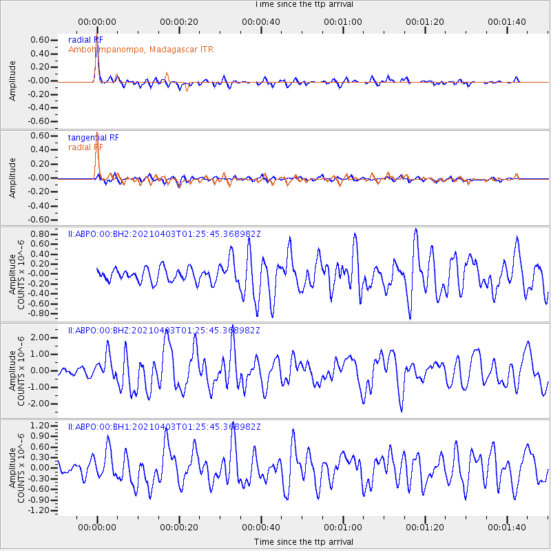
Signal To Noise
| Channel | StoN | STA | LTA |
| II:ABPO:00:BHZ:20210403T01:25:45.368982Z | 4.161386 | 7.428452E-7 | 1.7850907E-7 |
| II:ABPO:00:BH1:20210403T01:25:45.368982Z | 2.8678975 | 4.103182E-7 | 1.4307282E-7 |
| II:ABPO:00:BH2:20210403T01:25:45.368982Z | 2.092709 | 2.634678E-7 | 1.2589797E-7 |
| Arrivals |
| Ps | 12 SECOND |
| PpPs | 31 SECOND |
| PsPs/PpSs | 43 SECOND |


