You are here: Home > Network List > TA - USArray Transportable Network (new EarthScope stations) Stations List
> Station O17K Koliganek, Bristol Bay, AK, USA > Earthquake Result Viewer
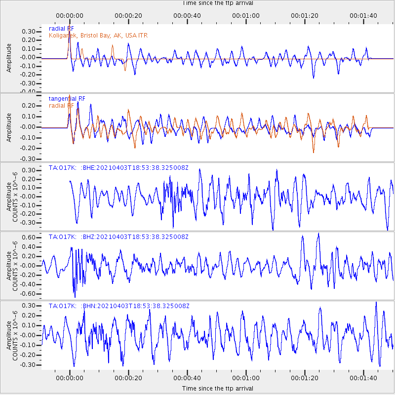
O17K Koliganek, Bristol Bay, AK, USA - Earthquake Result Viewer
*The percent match for this event was below the threshold and hence no stack was calculated.
| Earthquake location: |
Banda Sea |
| Earthquake latitude/longitude: |
-5.1/128.1 |
| Earthquake time(UTC): |
2021/04/03 (093) 18:42:01 GMT |
| Earthquake Depth: |
329 km |
| Earthquake Magnitude: |
5.9 Mww |
| Earthquake Catalog/Contributor: |
NEIC PDE/us |
|
| Network: |
TA USArray Transportable Network (new EarthScope stations) |
| Station: |
O17K Koliganek, Bristol Bay, AK, USA |
| Lat/Lon: |
59.77 N/157.09 W |
| Elevation: |
156 m |
|
| Distance: |
86.8 deg |
| Az: |
29.274 deg |
| Baz: |
254.3 deg |
| Ray Param: |
$rayparam |
*The percent match for this event was below the threshold and hence was not used in the summary stack. |
|
| Radial Match: |
57.52018 % |
| Radial Bump: |
400 |
| Transverse Match: |
48.351562 % |
| Transverse Bump: |
383 |
| SOD ConfigId: |
24334971 |
| Insert Time: |
2021-04-17 18:50:21.107 +0000 |
| GWidth: |
2.5 |
| Max Bumps: |
400 |
| Tol: |
0.001 |
|
Signal To Noise
| Channel | StoN | STA | LTA |
| TA:O17K: :BHZ:20210403T18:53:38.325008Z | 2.8515174 | 2.8940573E-7 | 1.01491835E-7 |
| TA:O17K: :BHN:20210403T18:53:38.325008Z | 1.4032086 | 1.4202548E-7 | 1.012148E-7 |
| TA:O17K: :BHE:20210403T18:53:38.325008Z | 1.0718786 | 1.1754746E-7 | 1.0966491E-7 |
| Arrivals |
| Ps | |
| PpPs | |
| PsPs/PpSs | |


