You are here: Home > Network List > UW - Pacific Northwest Regional Seismic Network Stations List
> Station YACT Amboy, WA, USA > Earthquake Result Viewer
YACT Amboy, WA, USA - Earthquake Result Viewer
| Earthquake location: |
Off E. Coast Of N. Island, N.Z. |
| Earthquake latitude/longitude: |
-37.5/179.7 |
| Earthquake time(UTC): |
2021/04/05 (095) 07:37:50 GMT |
| Earthquake Depth: |
10 km |
| Earthquake Magnitude: |
6.0 mww |
| Earthquake Catalog/Contributor: |
NEIC PDE/us |
|
| Network: |
UW Pacific Northwest Regional Seismic Network |
| Station: |
YACT Amboy, WA, USA |
| Lat/Lon: |
45.93 N/122.42 W |
| Elevation: |
211 m |
|
| Distance: |
98.0 deg |
| Az: |
36.662 deg |
| Baz: |
222.863 deg |
| Ray Param: |
0.040035576 |
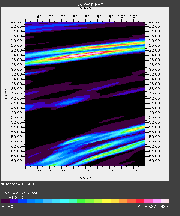
| Estimated Moho Depth: |
23.75 km |
| Estimated Crust Vp/Vs: |
1.83 |
| Assumed Crust Vp: |
6.566 km/s |
| Estimated Crust Vs: |
3.593 km/s |
| Estimated Crust Poisson's Ratio: |
0.29 |
|
| Radial Match: |
91.50393 % |
| Radial Bump: |
301 |
| Transverse Match: |
91.50394 % |
| Transverse Bump: |
301 |
| SOD ConfigId: |
24334971 |
| Insert Time: |
2021-04-19 07:47:54.359 +0000 |
| GWidth: |
2.5 |
| Max Bumps: |
400 |
| Tol: |
0.001 |
|

Signal To Noise
| Channel | StoN | STA | LTA |
| UW:YACT: :HHZ:20210405T07:50:55.240016Z | 1.4034003 | 1.5708444E-7 | 1.11931314E-7 |
| UW:YACT: :HHN:20210405T07:50:55.240016Z | 1.333923 | 2.1528425E-7 | 1.6139181E-7 |
| $trig.getChannelId() | $trig.getValue() | $trig.getSTA() | $trig.getLTA() |
| Arrivals |
| Ps | 3.1 SECOND |
| PpPs | 10 SECOND |
| PsPs/PpSs | 13 SECOND |


