You are here: Home > Network List > IW - Intermountain West Stations List
> Station DLMT Dillon, Montana, USA > Earthquake Result Viewer
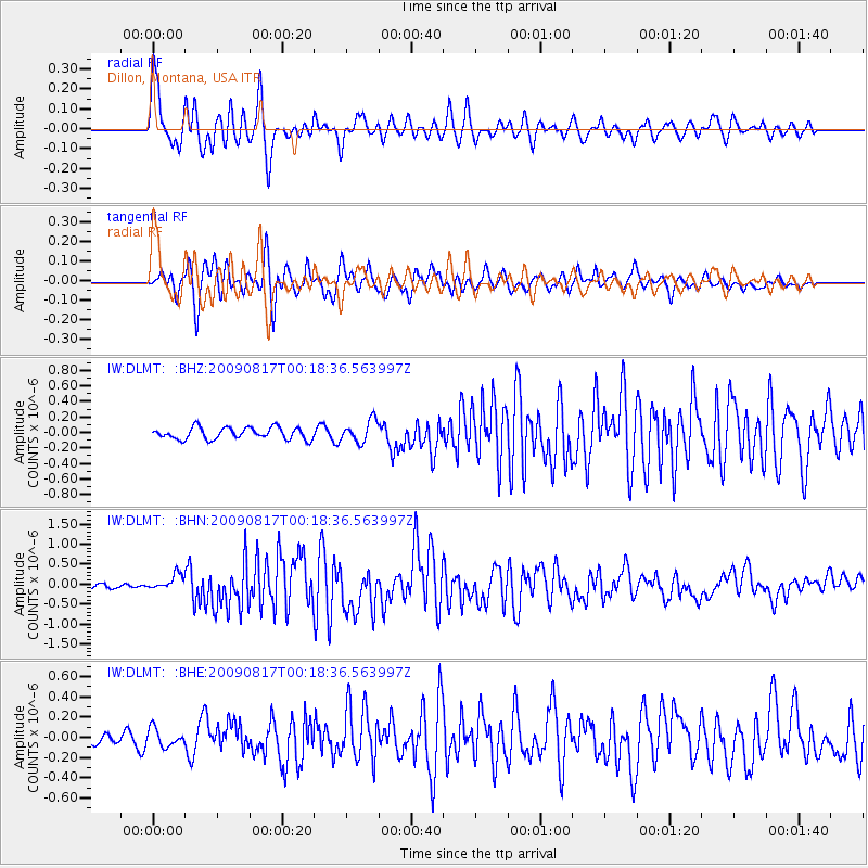
DLMT Dillon, Montana, USA - Earthquake Result Viewer

| Earthquake location: |
Southwestern Ryukyu Isl., Japan |
| Earthquake latitude/longitude: |
23.5/123.5 |
| Earthquake time(UTC): |
2009/08/17 (229) 00:05:49 GMT |
| Earthquake Depth: |
20 km |
| Earthquake Magnitude: |
6.2 MB, 6.6 MS, 6.7 MW, 6.6 MW |
| Earthquake Catalog/Contributor: |
WHDF/NEIC |
|
| Network: |
IW Intermountain West |
| Station: |
DLMT Dillon, Montana, USA |
| Lat/Lon: |
45.36 N/112.60 W |
| Elevation: |
1569 m |
|
| Distance: |
94.6 deg |
| Az: |
35.945 deg |
| Baz: |
310.149 deg |
| Ray Param: |
0.0410049 |
| Estimated Moho Depth: |
35.75 km |
| Estimated Crust Vp/Vs: |
2.10 |
| Assumed Crust Vp: |
6.577 km/s |
| Estimated Crust Vs: |
3.136 km/s |
| Estimated Crust Poisson's Ratio: |
0.35 |
|
| Radial Match: |
90.32389 % |
| Radial Bump: |
400 |
| Transverse Match: |
81.06149 % |
| Transverse Bump: |
400 |
| SOD ConfigId: |
2622 |
| Insert Time: |
2010-03-09 07:10:32.281 +0000 |
| GWidth: |
2.5 |
| Max Bumps: |
400 |
| Tol: |
0.001 |
|
Signal To Noise
| Channel | StoN | STA | LTA |
| IW:DLMT: :BHN:20090817T00:18:36.563997Z | 5.05213 | 1.9719424E-7 | 3.90319E-8 |
| IW:DLMT: :BHE:20090817T00:18:36.563997Z | 1.8698533 | 8.8081684E-8 | 4.71062E-8 |
| IW:DLMT: :BHZ:20090817T00:18:36.563997Z | 1.8627726 | 1.3925789E-7 | 7.47584E-8 |
| Arrivals |
| Ps | 6.1 SECOND |
| PpPs | 17 SECOND |
| PsPs/PpSs | 23 SECOND |


