You are here: Home > Network List > IW - Intermountain West Stations List
> Station DLMT Dillon, Montana, USA > Earthquake Result Viewer
DLMT Dillon, Montana, USA - Earthquake Result Viewer

| Earthquake location: |
North Of Honduras |
| Earthquake latitude/longitude: |
16.7/-86.2 |
| Earthquake time(UTC): |
2009/05/28 (148) 08:24:45 GMT |
| Earthquake Depth: |
10 km |
| Earthquake Magnitude: |
6.7 MB, 7.2 MS, 7.3 MW, 7.3 MW |
| Earthquake Catalog/Contributor: |
WHDF/NEIC |
|
| Network: |
IW Intermountain West |
| Station: |
DLMT Dillon, Montana, USA |
| Lat/Lon: |
45.36 N/112.60 W |
| Elevation: |
1569 m |
|
| Distance: |
36.1 deg |
| Az: |
327.895 deg |
| Baz: |
133.749 deg |
| Ray Param: |
0.07687003 |
| Estimated Moho Depth: |
51.75 km |
| Estimated Crust Vp/Vs: |
2.10 |
| Assumed Crust Vp: |
6.577 km/s |
| Estimated Crust Vs: |
3.136 km/s |
| Estimated Crust Poisson's Ratio: |
0.35 |
|
| Radial Match: |
90.745285 % |
| Radial Bump: |
400 |
| Transverse Match: |
85.370346 % |
| Transverse Bump: |
400 |
| SOD ConfigId: |
2648 |
| Insert Time: |
2010-03-09 07:10:52.827 +0000 |
| GWidth: |
2.5 |
| Max Bumps: |
400 |
| Tol: |
0.001 |
|
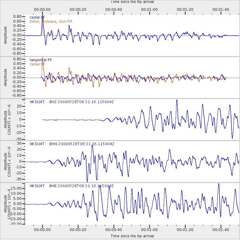
Signal To Noise
| Channel | StoN | STA | LTA |
| IW:DLMT: :BHN:20090528T08:31:16.115004Z | 18.977057 | 1.1809001E-6 | 6.222778E-8 |
| IW:DLMT: :BHE:20090528T08:31:16.115004Z | 5.2944765 | 5.320823E-7 | 1.0049763E-7 |
| IW:DLMT: :BHZ:20090528T08:31:16.115004Z | 7.364141 | 6.8543756E-7 | 9.307773E-8 |
| Arrivals |
| Ps | 9.2 SECOND |
| PpPs | 23 SECOND |
| PsPs/PpSs | 32 SECOND |


