You are here: Home > Network List > IW - Intermountain West Stations List
> Station DLMT Dillon, Montana, USA > Earthquake Result Viewer
DLMT Dillon, Montana, USA - Earthquake Result Viewer
| Earthquake location: |
Kuril Islands |
| Earthquake latitude/longitude: |
46.0/151.5 |
| Earthquake time(UTC): |
2009/04/07 (097) 04:23:33 GMT |
| Earthquake Depth: |
31 km |
| Earthquake Magnitude: |
6.5 MB, 6.8 MS, 6.9 MW, 6.9 MW |
| Earthquake Catalog/Contributor: |
WHDF/NEIC |
|
| Network: |
IW Intermountain West |
| Station: |
DLMT Dillon, Montana, USA |
| Lat/Lon: |
45.36 N/112.60 W |
| Elevation: |
1569 m |
|
| Distance: |
62.7 deg |
| Az: |
52.122 deg |
| Baz: |
308.763 deg |
| Ray Param: |
0.060013335 |
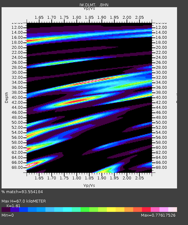
| Estimated Moho Depth: |
67.0 km |
| Estimated Crust Vp/Vs: |
1.61 |
| Assumed Crust Vp: |
6.577 km/s |
| Estimated Crust Vs: |
4.085 km/s |
| Estimated Crust Poisson's Ratio: |
0.19 |
|
| Radial Match: |
93.554184 % |
| Radial Bump: |
400 |
| Transverse Match: |
74.56478 % |
| Transverse Bump: |
400 |
| SOD ConfigId: |
2658 |
| Insert Time: |
2010-03-09 07:11:10.577 +0000 |
| GWidth: |
2.5 |
| Max Bumps: |
400 |
| Tol: |
0.001 |
|

Signal To Noise
| Channel | StoN | STA | LTA |
| IW:DLMT: :BHN:20090407T04:33:24.064001Z | 13.874055 | 3.936314E-6 | 2.837176E-7 |
| IW:DLMT: :BHE:20090407T04:33:24.064001Z | 3.1431003 | 9.908262E-7 | 3.1523845E-7 |
| IW:DLMT: :BHZ:20090407T04:33:24.064001Z | 3.1065452 | 1.7079427E-6 | 5.497884E-7 |
| Arrivals |
| Ps | 6.5 SECOND |
| PpPs | 25 SECOND |
| PsPs/PpSs | 32 SECOND |


