You are here: Home > Network List > IW - Intermountain West Stations List
> Station DLMT Dillon, Montana, USA > Earthquake Result Viewer
DLMT Dillon, Montana, USA - Earthquake Result Viewer

| Earthquake location: |
Eastern Honshu, Japan |
| Earthquake latitude/longitude: |
39.8/141.5 |
| Earthquake time(UTC): |
2008/07/23 (205) 15:26:19 GMT |
| Earthquake Depth: |
108 km |
| Earthquake Magnitude: |
6.6 MB, 6.8 MW, 6.8 MW |
| Earthquake Catalog/Contributor: |
WHDF/NEIC |
|
| Network: |
IW Intermountain West |
| Station: |
DLMT Dillon, Montana, USA |
| Lat/Lon: |
45.36 N/112.60 W |
| Elevation: |
1569 m |
|
| Distance: |
72.4 deg |
| Az: |
45.345 deg |
| Baz: |
308.986 deg |
| Ray Param: |
0.053448543 |
| Estimated Moho Depth: |
39.75 km |
| Estimated Crust Vp/Vs: |
1.84 |
| Assumed Crust Vp: |
6.577 km/s |
| Estimated Crust Vs: |
3.574 km/s |
| Estimated Crust Poisson's Ratio: |
0.29 |
|
| Radial Match: |
95.994736 % |
| Radial Bump: |
400 |
| Transverse Match: |
93.01475 % |
| Transverse Bump: |
400 |
| SOD ConfigId: |
2504 |
| Insert Time: |
2010-03-09 07:11:47.785 +0000 |
| GWidth: |
2.5 |
| Max Bumps: |
400 |
| Tol: |
0.001 |
|
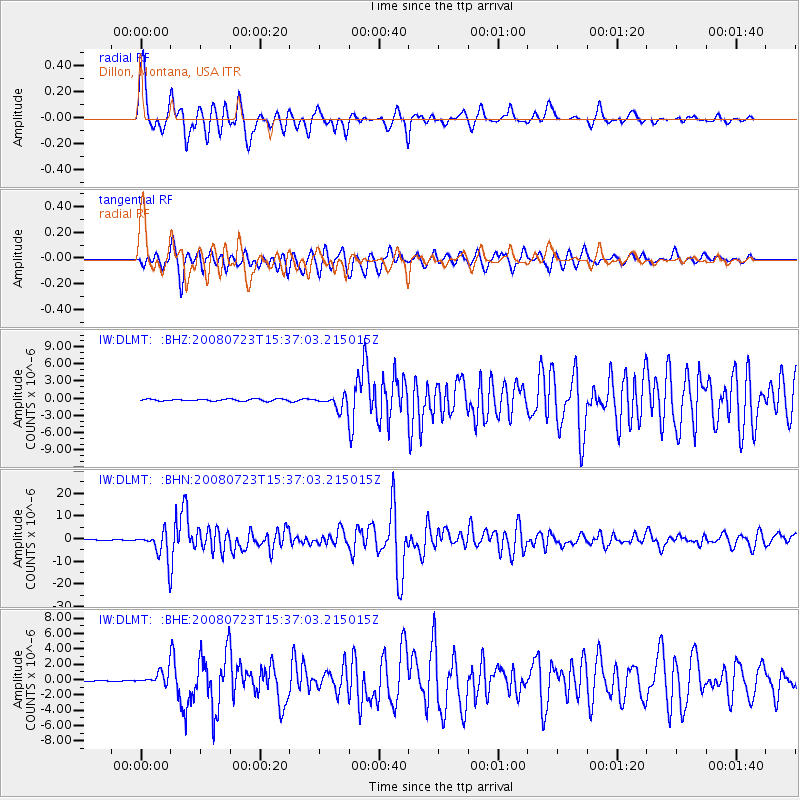
Signal To Noise
| Channel | StoN | STA | LTA |
| IW:DLMT: :BHN:20080723T15:37:03.215015Z | 80.1058 | 6.2263357E-6 | 7.77264E-8 |
| IW:DLMT: :BHE:20080723T15:37:03.215015Z | 7.237313 | 9.019382E-7 | 1.2462337E-7 |
| IW:DLMT: :BHZ:20080723T15:37:03.215015Z | 7.605957 | 1.2487252E-6 | 1.6417727E-7 |
| Arrivals |
| Ps | 5.3 SECOND |
| PpPs | 17 SECOND |
| PsPs/PpSs | 22 SECOND |


