You are here: Home > Network List > TA - USArray Transportable Network (new EarthScope stations) Stations List
> Station G16K Koyuk River, AK, USA > Earthquake Result Viewer
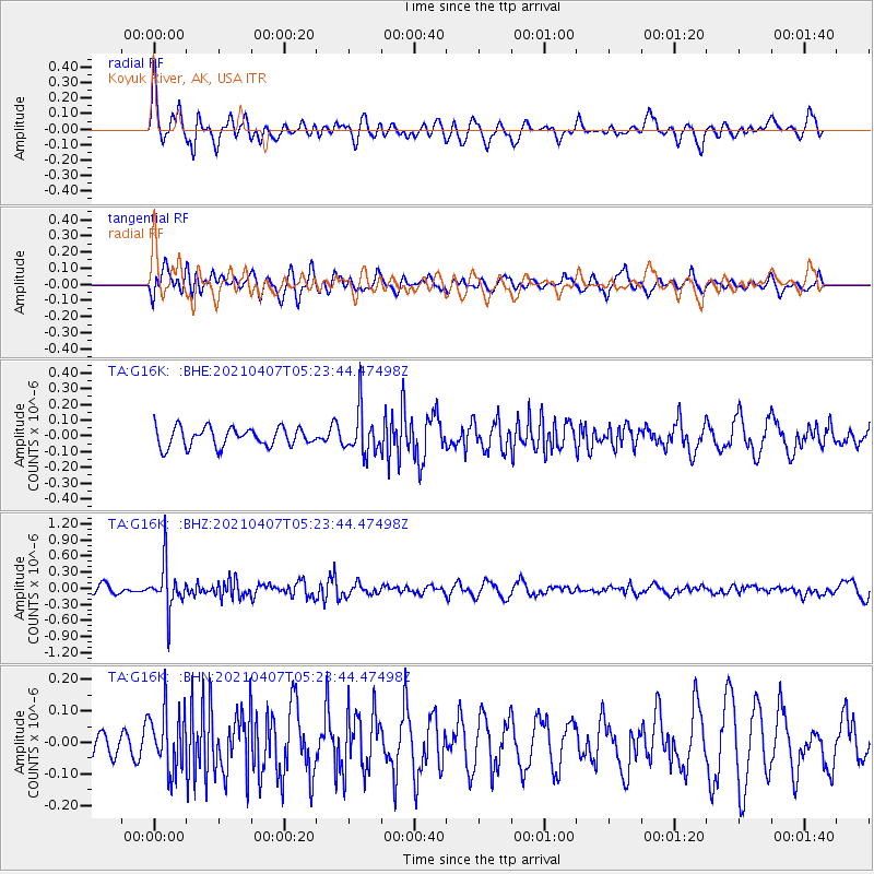
G16K Koyuk River, AK, USA - Earthquake Result Viewer
*The percent match for this event was below the threshold and hence no stack was calculated.
| Earthquake location: |
New Ireland Region, P.N.G. |
| Earthquake latitude/longitude: |
-3.6/154.0 |
| Earthquake time(UTC): |
2021/04/07 (097) 05:13:16 GMT |
| Earthquake Depth: |
448 km |
| Earthquake Magnitude: |
5.6 mww |
| Earthquake Catalog/Contributor: |
NEIC PDE/us |
|
| Network: |
TA USArray Transportable Network (new EarthScope stations) |
| Station: |
G16K Koyuk River, AK, USA |
| Lat/Lon: |
65.39 N/162.35 W |
| Elevation: |
169 m |
|
| Distance: |
75.8 deg |
| Az: |
17.347 deg |
| Baz: |
225.292 deg |
| Ray Param: |
$rayparam |
*The percent match for this event was below the threshold and hence was not used in the summary stack. |
|
| Radial Match: |
57.58799 % |
| Radial Bump: |
400 |
| Transverse Match: |
49.919037 % |
| Transverse Bump: |
400 |
| SOD ConfigId: |
24334971 |
| Insert Time: |
2021-04-21 05:27:29.959 +0000 |
| GWidth: |
2.5 |
| Max Bumps: |
400 |
| Tol: |
0.001 |
|
Signal To Noise
| Channel | StoN | STA | LTA |
| TA:G16K: :BHZ:20210407T05:23:44.47498Z | 5.069674 | 4.2674657E-7 | 8.4176335E-8 |
| TA:G16K: :BHN:20210407T05:23:44.47498Z | 1.402617 | 9.594803E-8 | 6.8406436E-8 |
| TA:G16K: :BHE:20210407T05:23:44.47498Z | 2.291276 | 1.3800276E-7 | 6.022965E-8 |
| Arrivals |
| Ps | |
| PpPs | |
| PsPs/PpSs | |


