You are here: Home > Network List > UW - Pacific Northwest Regional Seismic Network Stations List
> Station LON Longmire CREST broad-band > Earthquake Result Viewer
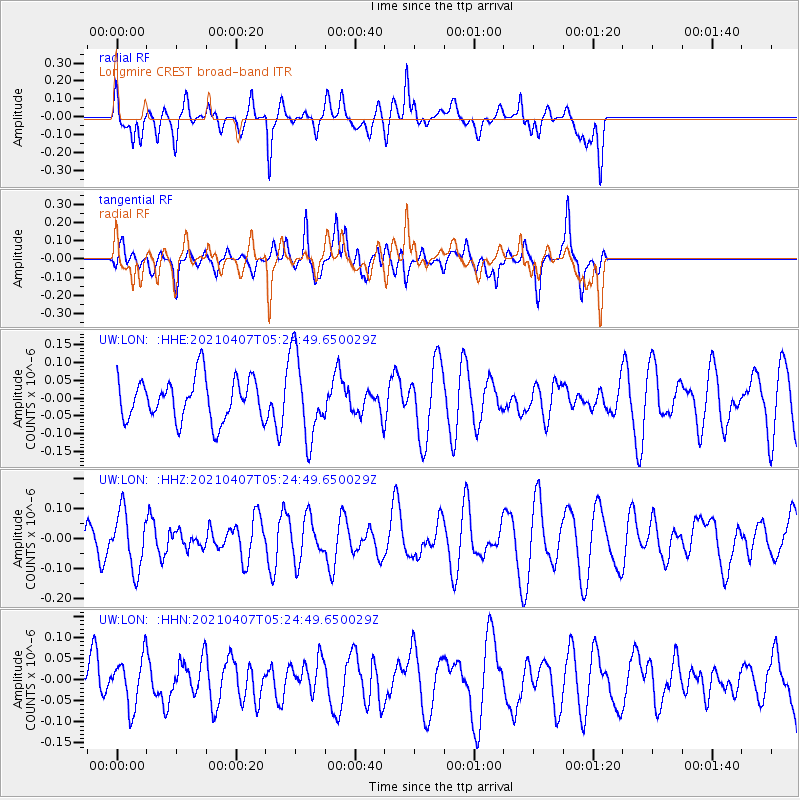
LON Longmire CREST broad-band - Earthquake Result Viewer
*The percent match for this event was below the threshold and hence no stack was calculated.
| Earthquake location: |
New Ireland Region, P.N.G. |
| Earthquake latitude/longitude: |
-3.6/154.0 |
| Earthquake time(UTC): |
2021/04/07 (097) 05:13:16 GMT |
| Earthquake Depth: |
448 km |
| Earthquake Magnitude: |
5.6 mww |
| Earthquake Catalog/Contributor: |
NEIC PDE/us |
|
| Network: |
UW Pacific Northwest Regional Seismic Network |
| Station: |
LON Longmire CREST broad-band |
| Lat/Lon: |
46.75 N/121.81 W |
| Elevation: |
853 m |
|
| Distance: |
88.7 deg |
| Az: |
43.18 deg |
| Baz: |
263.31 deg |
| Ray Param: |
$rayparam |
*The percent match for this event was below the threshold and hence was not used in the summary stack. |
|
| Radial Match: |
53.245823 % |
| Radial Bump: |
400 |
| Transverse Match: |
70.03147 % |
| Transverse Bump: |
400 |
| SOD ConfigId: |
24334971 |
| Insert Time: |
2021-04-21 05:29:46.528 +0000 |
| GWidth: |
2.5 |
| Max Bumps: |
400 |
| Tol: |
0.001 |
|
Signal To Noise
| Channel | StoN | STA | LTA |
| UW:LON: :HHZ:20210407T05:24:49.650029Z | 0.95527965 | 9.4919706E-8 | 9.936327E-8 |
| UW:LON: :HHN:20210407T05:24:49.650029Z | 1.1668385 | 5.7131096E-8 | 4.89623E-8 |
| UW:LON: :HHE:20210407T05:24:49.650029Z | 1.9738423 | 1.1745894E-7 | 5.9507762E-8 |
| Arrivals |
| Ps | |
| PpPs | |
| PsPs/PpSs | |


