You are here: Home > Network List > IW - Intermountain West Stations List
> Station DLMT Dillon, Montana, USA > Earthquake Result Viewer
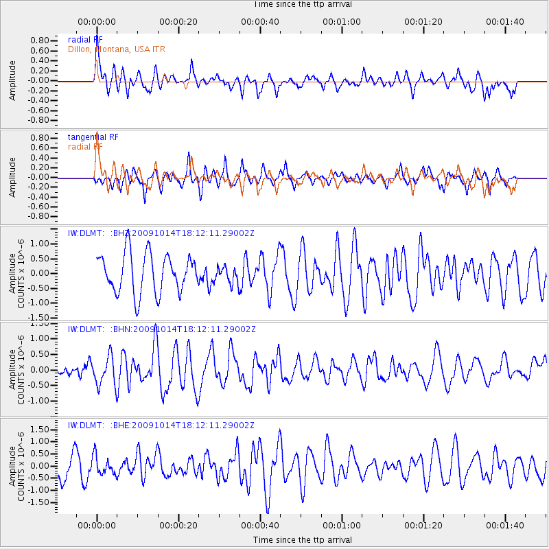
DLMT Dillon, Montana, USA - Earthquake Result Viewer
*The percent match for this event was below the threshold and hence no stack was calculated.
| Earthquake location: |
Samoa Islands Region |
| Earthquake latitude/longitude: |
-14.9/-174.8 |
| Earthquake time(UTC): |
2009/10/14 (287) 18:00:21 GMT |
| Earthquake Depth: |
10 km |
| Earthquake Magnitude: |
5.7 MB, 6.0 MS, 6.3 MW, 6.2 MW |
| Earthquake Catalog/Contributor: |
WHDF/NEIC |
|
| Network: |
IW Intermountain West |
| Station: |
DLMT Dillon, Montana, USA |
| Lat/Lon: |
45.36 N/112.60 W |
| Elevation: |
1569 m |
|
| Distance: |
82.2 deg |
| Az: |
39.025 deg |
| Baz: |
239.705 deg |
| Ray Param: |
$rayparam |
*The percent match for this event was below the threshold and hence was not used in the summary stack. |
|
| Radial Match: |
61.38912 % |
| Radial Bump: |
400 |
| Transverse Match: |
80.26467 % |
| Transverse Bump: |
400 |
| SOD ConfigId: |
2622 |
| Insert Time: |
2010-03-09 07:12:45.936 +0000 |
| GWidth: |
2.5 |
| Max Bumps: |
400 |
| Tol: |
0.001 |
|
Signal To Noise
| Channel | StoN | STA | LTA |
| IW:DLMT: :BHN:20091014T18:12:11.29002Z | 2.2464926 | 4.7450422E-7 | 2.1122003E-7 |
| IW:DLMT: :BHE:20091014T18:12:11.29002Z | 0.7722418 | 3.8175534E-7 | 4.9434686E-7 |
| IW:DLMT: :BHZ:20091014T18:12:11.29002Z | 0.4277824 | 2.83528E-7 | 6.627856E-7 |
| Arrivals |
| Ps | |
| PpPs | |
| PsPs/PpSs | |


